
1932 Map of Barstow
USGS Topo · Published 1956About this map
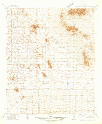
The Mojave River serves as the vital lifeline through this arid High Desert landscape, its course dictates the corridor for both the Atchison Topeka and Santa Fe RR and early regional roads. The topography is defined by significant island-like formations such as Iron Mountain, Sidewinder Mtn, and the Granite Mountain range, which ring the expansive flats of Hinkley Valley and Apple Valley.
Find a feature on this map
48 named features on this map. Tap any name to fly to it.
Don’t see what you’re looking for? This feature index may not catch every label — zoom into the map to look around manually.
Map Details
Editions of this 1932 Barstow Map
This is the sole edition of this map. No revisions or reprints were ever made.
Other maps of this area

1901 · Southern California Sheet No. 1
USGS Topo · 1:250,000

1902 · Deep Creek
USGS Topo · 1:62,500

1902 · Hesperia
USGS Topo · 1:62,500

1902 · San Gorgonio
USGS Topo · 1:125,000

1903 · San Antonio
USGS Topo · 1:62,500

1904 · Southern California Sheet No. 1
USGS Topo · 1:250,000

1915 · Searles Lake
USGS Topo · 1:250,000

1933 · Avawatz Mountains
USGS Topo · 1:250,000

1934 · Barstow
USGS Topo · 1:125,000
1937 · Shadow Mountains
USGS Topo · 1:48,000