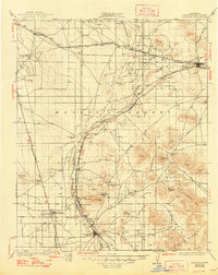
1934 Map of Barstow
USGS Topo · Published 1948About this map
The Mojave River defines the corridor of settlement and transport through this high desert region, its course closely tracked by the Atchison Topeka and Santa Fe RR. This rail-and-water lifeline connects a series of early communities from Victorville and Oro Grande in the south up toward Barstow and Hinkley. The landscape is dominated by mining interests and desert ranching, as evidenced by the Red Raven Mine and Western States Mine, as well as several established wells like Stoddard Well and Sidewinder Well that supported travelers and livestock in an arid climate.
Find a feature on this map
45 named features on this map. Tap any name to fly to it.
Don’t see what you’re looking for? This feature index may not catch every label — zoom into the map to look around manually.
Map Details
Editions of this 1934 Barstow Map
3 editions found
Other maps of this area

1901 · Southern California Sheet No. 1
USGS Topo · 1:250,000

1902 · Deep Creek
USGS Topo · 1:62,500

1902 · Hesperia
USGS Topo · 1:62,500

1902 · San Gorgonio
USGS Topo · 1:125,000

1903 · San Antonio
USGS Topo · 1:62,500

1904 · Southern California Sheet No. 1
USGS Topo · 1:250,000

1915 · Searles Lake
USGS Topo · 1:250,000

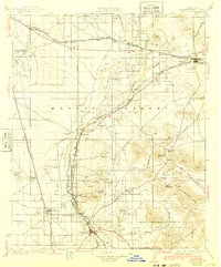
1932 · Barstow
USGS Topo · 1:125,000

1933 · Avawatz Mountains
USGS Topo · 1:250,000

1934 · Barstow
USGS Topo · 1:125,000