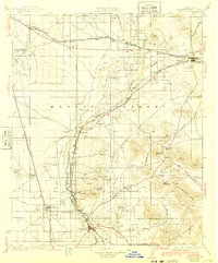
1934 Map of Barstow
USGS Topo · Published 1940About this map
The Mojave River carves a distinctive path through the high desert, anchoring a chain of early 20th-century settlements and industrial sites. In this era, the Atchison Topeka and Santa Fe railroad corridor dictates the region's geography, connecting hubs like Barstow and Victorville with smaller sidings and ranching outposts. The map reveals a landscape defined by transit and extraction, with Oro Grande and Helendale situated along the riverbank while mining operations like the Red Raven Mine and Sidewinder Mine dot the surrounding mountains. Significant topographic markers such as Point of Rocks and the Upper Narrows near Victorville provide historical context for early travel routes. The presence of Las Cruces Ranch and numerous named wells like Stoddard Well illustrates the critical role of water management in sustaining these desert communities before widespread modernization.
Find a feature on this map
45 named features on this map. Tap any name to fly to it.
Don’t see what you’re looking for? This feature index may not catch every label — zoom into the map to look around manually.
Map Details
Editions of this 1934 Barstow Map
3 editions found
Other maps of this area

1901 · Southern California Sheet No. 1
USGS Topo · 1:250,000

1902 · Deep Creek
USGS Topo · 1:62,500

1902 · Hesperia
USGS Topo · 1:62,500

1902 · San Gorgonio
USGS Topo · 1:125,000

1903 · San Antonio
USGS Topo · 1:62,500

1904 · Southern California Sheet No. 1
USGS Topo · 1:250,000

1915 · Searles Lake
USGS Topo · 1:250,000

1932 · Barstow
USGS Topo · 1:125,000

1933 · Avawatz Mountains
USGS Topo · 1:250,000

1934 · Barstow
USGS Topo · 1:125,000