Old Maps of Hesperia, California
Explore 24 old maps of Hesperia, spanning from 1901 to today. These high-resolution historic maps reveal how streets, neighborhoods, landmarks, and natural features evolved over time — perfect for genealogy, metal detecting, research, and local history exploration.
What you can do with these maps:
- See how Hesperia changed over time: Compare historical maps to modern-day views to trace roads, homesites, rail lines & more.
- View detailed metadata: Each map includes creators, publishers, year, scale, and archive source.
- Overlay maps with satellite & LiDAR: Visualize the past alongside modern tools to explore terrain & human change.
- Trusted historical sources: Maps sourced from the USGS, Library of Congress, and other archives.
- Access maps your way: View online, download high-res files, or order prints for personal or research use.
Start exploring old maps of Hesperia to uncover forgotten places, hidden landmarks, and the deep history beneath your feet.
Hesperia, CA maps
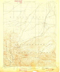
(24)- 1901 Map of Southern California Sheet No. 1
 1901 Southern California Sheet No. 11901 Print · USGSCovers Hesperia, including Los Angeles, Long Beach, and other nearby areas11 unique versions available
 - 1902 Map of Deep Creek
 1902 Deep Creek1902 Print · USGSCovers Hesperia, including Apple Valley, Fizzben Heights, and other nearby areas8 unique versions available
 - 1902 Map of Hesperia
 1902 Hesperia1902 Print · USGSCovers Hesperia, including Victorville, Apple Valley, and other nearby areas7 unique versions available
 - 1904 Map of Southern California Sheet No. 1, 1905 Print
 1904 Southern California Sheet No. 11905 Print · USGSCovers Hesperia, including Los Angeles, Long Beach, and other nearby areas3 unique versions available
 - 1942 Map of Hesperia
 1942 Hesperia1942 Print · USGSCovers Hesperia, including Victorville, Apple Valley, and other nearby areas
 - 1953 Map of San Bernardino
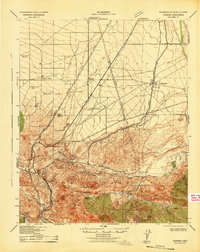
 1953 San Bernardino1953 Print · USGSCovers Hesperia, including Riverside, Fontana, and other nearby areas2 unique versions available
 - 1956 Map of San Bernardino
 1956 San Bernardino1956 Print · USGSCovers Hesperia, including Riverside, Fontana, and other nearby areas
 - 1956 Map of Cajon, 1957 Print
 1956 Cajon1957 Print · USGSCovers Hesperia, including Cajon, Lytle Creek, and other nearby areas8 unique versions available
 - 1956 Map of Baldy Mesa, 1957 Print
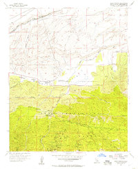
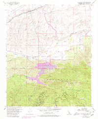
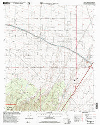
 1956 Baldy Mesa1957 Print · USGSCovers Hesperia, including Victorville, Oak Hills, and other nearby areas8 unique versions available
 - 1956 Map of Hesperia, 1957 Print
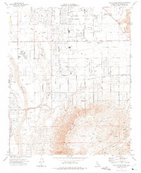
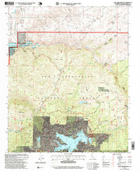
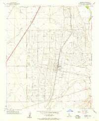 1956 Hesperia1957 Print · USGSCovers Hesperia, including Victorville, Apple Valley, and other nearby areas6 unique versions available
 - 1956 Map of Cedar Springs, 1957 Print
 1956 Cedar Springs1957 Print · USGSCovers Hesperia, including Cedarpines Park, San Bernardino County, and other nearby areas7 unique versions available
 - 1956 Map of Lake Arrowhead, 1957 Print
 1956 Lake Arrowhead1957 Print · USGSCovers Hesperia, including Apple Valley, Fizzben Heights, and other nearby areas5 unique versions available
 - 1957 Map of San Bernardino
 1957 San Bernardino1957 Print · USGSCovers Hesperia, including Riverside, Fontana, and other nearby areas
 - 1958 Map of San Bernardino, 1975 Print
 1958 San Bernardino1975 Print · USGSCovers Hesperia, including Riverside, Fontana, and other nearby areas
 - 1959 Map of San Bernardino
 1959 San Bernardino1959 Print · USGSCovers Hesperia, including Riverside, Fontana, and other nearby areas
 - 1966 Map of San Bernardino
 1966 San Bernardino1966 Print · USGSCovers Hesperia, including Riverside, Fontana, and other nearby areas
 - 1971 Map of Lake Arrowhead, 1975 Print
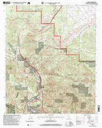
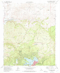 1971 Lake Arrowhead1975 Print · USGSCovers Hesperia, including Arrowhead Equestrian Estates, Cedar Glen, and other nearby areas4 unique versions available
 - 1971 Map of Apple Valley South, 1975 Print
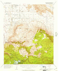
 1971 Apple Valley South1975 Print · USGSCovers Hesperia, including Apple Valley, Mariana Ranchos, and other nearby areas7 unique versions available
 - 1973 Map of Silverwood Lake, 1980 Print
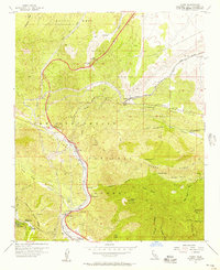
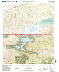
 1973 Silverwood Lake1980 Print · USGSCovers Hesperia, including Cedarpines Park, San Bernardino County, and other nearby areas
 - 1982 Map of San Bernardino, 1983 Print
 1982 San Bernardino1983 Print · USGSCovers Hesperia, including Riverside, Fontana, and other nearby areas
 - 1996 Map of Silverwood Lake, 1999 Print
 1996 Silverwood Lake1999 Print · USGSCovers Hesperia, including Cedarpines Park, San Bernardino County, and other nearby areas
 - 1996 Map of Cajon, 1999 Print
 1996 Cajon1999 Print · USGSCovers Hesperia, including Cajon, Lytle Creek, and other nearby areas
 - 1996 Map of Lake Arrowhead, 1999 Print
 1996 Lake Arrowhead1999 Print · USGSCovers Hesperia, including Arrowhead Equestrian Estates, Cedar Glen, and other nearby areas
 - 1996 Map of Baldy Mesa, 1999 Print
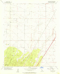
 1996 Baldy Mesa1999 Print · USGSCovers Hesperia, including Victorville, Oak Hills, and other nearby areas
End of results
Showing maps 1-24 of 24
Top cities near Hesperia
- Fontana historical maps
- Rancho Cucamonga historical maps
- Victorville historical maps
- Rialto historical maps
- Apple Valley historical maps
- Adelanto historical maps
See more
Top neighborhoods of Hesperia
Frequently asked questions
- What are the different types of historical maps available for Hesperia?
- What is the oldest map of Hesperia?
- Where can I purchase historical maps of Hesperia for my home or office?
- Where can I download high-res historical maps of Hesperia?
- Are there historical topographic maps available for Hesperia?
- Is there historical aerial imagery available for Hesperia?
- Where are historical maps of Hesperia sourced from?