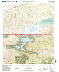
1996 Map of Silverwood Lake
USGS Topo · Published 1999About this map
Silverwood Lake serves as a central reservoir within the Silverwood Lake State Recreation Area, reflecting the complex water management systems of the late 20th century. The California Aqueduct flows through the northern reaches of the Antelope Valley, emphasizing the engineering required to move water across this arid landscape. This map details the intersection of high-desert terrain and the San Bernardino National Forest, where the West Fork Mojave River and Mojave River meet near the Forks Reservoir. Local history is captured in landmarks like Las Flores Ranch and the Las Flores School, while the southern portion of the sheet highlights recreational and community nodes such as Camp Seeley and the residential area of Cedarpines Park. The presence of the Pacific Crest National Scenic Trail and the Rim of the World Scenic Byway illustrates the area's importance as a gateway for outdoor transit.
Find a feature on this map
35 named features on this map. Tap any name to fly to it.
Don’t see what you’re looking for? This feature index may not catch every label — zoom into the map to look around manually.
Map Details
Editions of this 1996 Silverwood Lake Map
This is the sole edition of this map. No revisions or reprints were ever made.
Other maps of this area

1896 · San Bernardino
USGS Topo · 1:62,500

1898 · San Bernardino
USGS Topo · 1:62,500

1899 · Redlands
USGS Topo · 1:62,500

1901 · Southern California Sheet No. 1
USGS Topo · 1:250,000

1901 · San Bernardino
USGS Topo · 1:62,500

1901 · Redlands
USGS Topo · 1:62,500

1902 · Deep Creek
USGS Topo · 1:62,500

1902 · Hesperia
USGS Topo · 1:62,500

1904 · Southern California Sheet No. 1
USGS Topo · 1:250,000

1936 · Devore
USGS Topo · 1:31,680