1936 Map of Devore
USGS Topo · Published 1936About this map
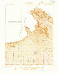
San Bernardino National Forest dominates the northern reaches of this mid-1930s landscape, where the rugged terrain meets the expanding agricultural and infrastructure networks of the valley below. The Atchison Topeka and Santa Fe RR and US Highway Nos 66 and 395 serve as critical arteries through the pass, flanking the settlement of Devore. Evidence of early aviation and utility development is prominent, including the Fontana Intermediate Landing Field, an Airway Beacon, and the Fontana Power Plant.
Find a feature on this map
41 named features on this map. Tap any name to fly to it.
Don’t see what you’re looking for? This feature index may not catch every label — zoom into the map to look around manually.
Map Details
Editions of this 1936 Devore Map
This is the sole edition of this map. No revisions or reprints were ever made.
Other maps of this area

1896 · San Bernardino
USGS Topo · 1:62,500

1897 · Cucamonga
USGS Topo · 1:62,500

1898 · San Bernardino
USGS Topo · 1:62,500

1900 · Cucamonga
USGS Topo · 1:62,500

1901 · Southern California Sheet No. 1
USGS Topo · 1:250,000

1901 · San Bernardino
USGS Topo · 1:62,500

1902 · Hesperia
USGS Topo · 1:62,500

1903 · Cucamonga
USGS Topo · 1:62,500

1903 · San Antonio
USGS Topo · 1:62,500

1904 · Southern California Sheet No. 1
USGS Topo · 1:250,000