1970s Maps of Lenwood, California
Explore 2 historic maps of Lenwood from the 1970s. These maps offer a rare glimpse into what life looked like during the 1970s — showing old roads, neighborhoods, homes, and landmarks that have changed or disappeared over time.
Whether you're researching your family's past, planning a metal detecting trip, or studying how Lenwood's landscape evolved across the 1970s, these high-resolution maps are a powerful tool for exploring the history of this region.
- Focus on a specific era: All maps on this page are from the 1970s, giving you a focused view of this time period.
- See what’s changed: Compare century-old streets, trails, and buildings to today's modern landscape using overlays and satellite layers.
- Research with precision: Use these maps for genealogy, historical research, land use analysis, or educational projects.
- View, download, or print: Maps are fully viewable online in high resolution, and can be downloaded or printed for your own records.
Start exploring Lenwood's history through authentic maps from the 1970s. This is your window into the past.
Lenwood, CA maps
(2)- 1971 Map of Barstow SE, 1973 Print
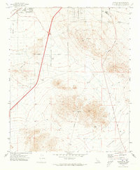 1971 Barstow SE1973 Print · USGSThe Mojave Desert settlement of Lenwood and the southern expansion of Barstow are captured here just as the region's modern infrastructure was solidifying. Researchers can trace historical land use through local landmarks like Barstow College, the Drive-in Theater, and various mining Prospects near STODDARD WELL ROAD.2 unique versions available
 - 1971 Map of Barstow, 1974 Print
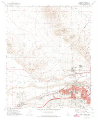 1971 Barstow1974 Print · USGSThe Mojave River valley thrived as a major California rail and logistics hub in the early seventies. Genealogists and historians can trace the growth of Barstow neighborhoods and locate landmarks like Mt View Cem and the Waterman Mine.5 unique versions available
End of results
Showing maps 1-2 of 2
Top cities near Lenwood
Top neighborhoods of Lenwood
Frequently asked questions
- What are the different types of historical maps available for Lenwood?
- What is the oldest map of Lenwood?
- Where can I purchase historical maps of Lenwood for my home or office?
- Where can I download high-res historical maps of Lenwood?
- Are there historical topographic maps available for Lenwood?
- Is there historical aerial imagery available for Lenwood?
- Where are historical maps of Lenwood sourced from?