1990s Maps of Muscoy, California
Explore 1 historic maps of Muscoy from the 1990s. These maps offer a rare glimpse into what life looked like during the 1990s — showing old roads, neighborhoods, homes, and landmarks that have changed or disappeared over time.
Whether you're researching your family's past, planning a metal detecting trip, or studying how Muscoy's landscape evolved across the 1990s, these high-resolution maps are a powerful tool for exploring the history of this region.
- Focus on a specific era: All maps on this page are from the 1990s, giving you a focused view of this time period.
- See what’s changed: Compare century-old streets, trails, and buildings to today's modern landscape using overlays and satellite layers.
- Research with precision: Use these maps for genealogy, historical research, land use analysis, or educational projects.
- View, download, or print: Maps are fully viewable online in high resolution, and can be downloaded or printed for your own records.
Start exploring Muscoy's history through authentic maps from the 1990s. This is your window into the past.
Muscoy, CA maps
(1)- 1996 Map of San Bernardino North, 1999 Print
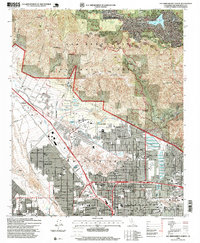 1996 San Bernardino North1999 Print · USGSSan Bernardino and the southern mountains are shown here in the mid-nineties, capturing the city’s expansion toward the forest boundary. Researchers can trace local heritage through landmarks like Pioneer Cem, Holy Rosary Academy, and the Arrowhead Country Club.
End of results
Showing maps 1-1 of 1
Top cities near Muscoy
- Riverside historical maps
- Fontana historical maps
- Moreno Valley historical maps
- Ontario historical maps
- Rancho Cucamonga historical maps
- Rialto historical maps
See more
Frequently asked questions
- What are the different types of historical maps available for Muscoy?
- What is the oldest map of Muscoy?
- Where can I purchase historical maps of Muscoy for my home or office?
- Where can I download high-res historical maps of Muscoy?
- Are there historical topographic maps available for Muscoy?
- Is there historical aerial imagery available for Muscoy?
- Where are historical maps of Muscoy sourced from?