1980s Maps of Old Dale, California
Explore 3 historic maps of Old Dale from the 1980s. These maps offer a rare glimpse into what life looked like during the 1980s — showing old roads, neighborhoods, homes, and landmarks that have changed or disappeared over time.
Whether you're researching your family's past, planning a metal detecting trip, or studying how Old Dale's landscape evolved across the 1980s, these high-resolution maps are a powerful tool for exploring the history of this region.
- Focus on a specific era: All maps on this page are from the 1980s, giving you a focused view of this time period.
- See what’s changed: Compare century-old streets, trails, and buildings to today's modern landscape using overlays and satellite layers.
- Research with precision: Use these maps for genealogy, historical research, land use analysis, or educational projects.
- View, download, or print: Maps are fully viewable online in high resolution, and can be downloaded or printed for your own records.
Start exploring Old Dale's history through authentic maps from the 1980s. This is your window into the past.
Old Dale, CA maps
(3)- 1981 Map of Needles, 1987 Print
 1981 Needles1987 Print · USGSThe High Desert and Colorado River valley are seen here in the early 1980s through the unique lens of satellite imagery. Trace the isolated outposts of the AT & SF railroad at Goffs and Essex, or explore the sprawling shores of Lake Havasu.
 - 1985 Map of Humbug Mountain
 1985 Humbug Mountain1985 Print · USGSSan Bernardino and Riverside counties are shown here in the 1980s as the high desert mining era left its mark on the land. Discover the specific locations of historic claims like the Imperial Mine, Virginia Dale Mine, and the Ruins Old Mill Site.
 - 1985 Map of Sheep Hole Mountains
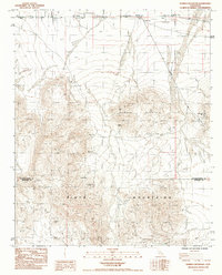
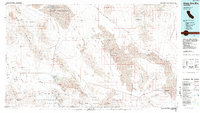 1985 Sheep Hole Mountains1985 Print · USGSThe high desert of San Bernardino County is revealed in the mid-eighties as a landscape of remote mines and vast salt basins. Genealogists and historians can trace the mining history of Old Dale or locate rail stops like Chubbuck and Milligan near the Iron Mountains.
End of results
Showing maps 1-3 of 3
Top cities near Old Dale
Frequently asked questions
- What are the different types of historical maps available for Old Dale?
- What is the oldest map of Old Dale?
- Where can I purchase historical maps of Old Dale for my home or office?
- Where can I download high-res historical maps of Old Dale?
- Are there historical topographic maps available for Old Dale?
- Is there historical aerial imagery available for Old Dale?
- Where are historical maps of Old Dale sourced from?