1940s Maps of San Bernardino, California
Explore 4 historic maps of San Bernardino from the 1940s. These maps offer a rare glimpse into what life looked like during the 1940s — showing old roads, neighborhoods, homes, and landmarks that have changed or disappeared over time.
Whether you're researching your family's past, planning a metal detecting trip, or studying how San Bernardino's landscape evolved across the 1940s, these high-resolution maps are a powerful tool for exploring the history of this region.
- Focus on a specific era: All maps on this page are from the 1940s, giving you a focused view of this time period.
- See what’s changed: Compare century-old streets, trails, and buildings to today's modern landscape using overlays and satellite layers.
- Research with precision: Use these maps for genealogy, historical research, land use analysis, or educational projects.
- View, download, or print: Maps are fully viewable online in high resolution, and can be downloaded or printed for your own records.
Start exploring San Bernardino's history through authentic maps from the 1940s. This is your window into the past.
San Bernardino, CA maps
(4)- 1941 Map of Devore
 1941 Devore1941 Print · USGSThe Cajon Pass area in the early 1940s reveals a landscape defined by critical rail lines and alluvial washes. Researchers can trace the development of infrastructure around Devore through landmarks like the Cajon Sch, Fontana Airport, and the Glenn Helen Infirmary.2 unique versions available
 - 1941 Map of Arrowhead
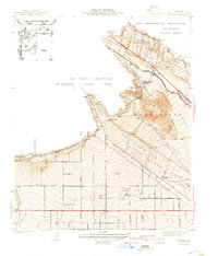
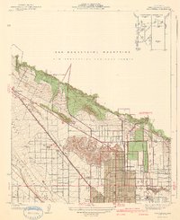 1941 Arrowhead1941 Print · USGSSan Bernardino expanded toward the mountain front during the late thirties and early forties. Trace the complex rail networks of the Union Pacific and Pacific Electric through old neighborhoods like Ono, Muscoy, and Del Rosa.2 unique versions available
 - 1942 Map of San Bernardino
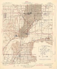
 1942 San Bernardino1942 Print · USGSThe San Bernardino Valley flourished as a railroad and citrus hub during the early years of the war. Researchers can trace the extensive tracks of the Atchison Topeka and Santa Fe, the National Orange Show grounds, and local landmarks like the Loma Linda Sanatorium.
 - 1943 Map of Colton
 1943 Colton1943 Print · USGSThe Inland Empire’s rail and citrus heritage is on full display during the early 1940s as industry expands around the San Bernardino line. Trace the historic convergence of the Southern Pacific and Union Pacific near Slover Mtn and the National Orange Show grounds.2 unique versions available
End of results
Showing maps 1-4 of 4
Top cities near San Bernardino
- Riverside historical maps
- Fontana historical maps
- Moreno Valley historical maps
- Ontario historical maps
- Rancho Cucamonga historical maps
- Rialto historical maps
See more
Top neighborhoods of San Bernardino
- Arrowhead Village historical maps
- Del Rosa historical maps
- North Loma Linda historical maps
- Serrano Village historical maps
- University Heights historical maps
- Valley Gardens historical maps
See more
Frequently asked questions
- What are the different types of historical maps available for San Bernardino?
- What is the oldest map of San Bernardino?
- Where can I purchase historical maps of San Bernardino for my home or office?
- Where can I download high-res historical maps of San Bernardino?
- Are there historical topographic maps available for San Bernardino?
- Is there historical aerial imagery available for San Bernardino?
- Where are historical maps of San Bernardino sourced from?