1990s Maps of San Bernardino, California
Explore 4 historic maps of San Bernardino from the 1990s. These maps offer a rare glimpse into what life looked like during the 1990s — showing old roads, neighborhoods, homes, and landmarks that have changed or disappeared over time.
Whether you're researching your family's past, planning a metal detecting trip, or studying how San Bernardino's landscape evolved across the 1990s, these high-resolution maps are a powerful tool for exploring the history of this region.
- Focus on a specific era: All maps on this page are from the 1990s, giving you a focused view of this time period.
- See what’s changed: Compare century-old streets, trails, and buildings to today's modern landscape using overlays and satellite layers.
- Research with precision: Use these maps for genealogy, historical research, land use analysis, or educational projects.
- View, download, or print: Maps are fully viewable online in high resolution, and can be downloaded or printed for your own records.
Start exploring San Bernardino's history through authentic maps from the 1990s. This is your window into the past.
San Bernardino, CA maps
(4)- 1996 Map of Harrison Mountain, 1999 Print
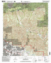 1996 Harrison Mountain1999 Print · USGSThe San Bernardino mountains meet the valley floor in the 1990s, capturing the interface between urban growth and forest wilderness. Genealogists and researchers can trace the developed grounds of Patton State Hospital and the mountain community at Strawberry Flat.
 - 1996 Map of Devore, 1999 Print
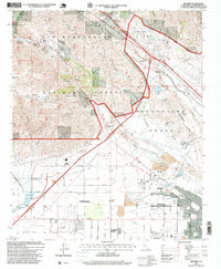 1996 Devore1999 Print · USGSIn the mid-1990s, the Cajon Pass gateway shows a landscape of mountain ridges and burgeoning valley cities. Genealogists and historians can trace family-named landmarks like Nealeys Corner and Hitching Ranch alongside the busy Southern Pacific rail corridors.
 - 1996 Map of San Bernardino North, 1999 Print
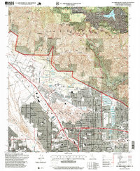 1996 San Bernardino North1999 Print · USGSSan Bernardino and the southern mountains are shown here in the mid-nineties, capturing the city’s expansion toward the forest boundary. Researchers can trace local heritage through landmarks like Pioneer Cem, Holy Rosary Academy, and the Arrowhead Country Club.
 - 1996 Map of Redlands, 1999 Print
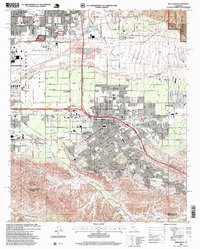 1996 Redlands1999 Print · USGSThe San Bernardino Valley in the mid-nineties shows a landscape of citrus-era heritage and modern expansion. Genealogists and historians can trace local landmarks from Hillside Cem to the San Bernardino Asistencia and the historic Mission Zanja canal.
End of results
Showing maps 1-4 of 4
Top cities near San Bernardino
- Riverside historical maps
- Fontana historical maps
- Moreno Valley historical maps
- Ontario historical maps
- Rancho Cucamonga historical maps
- Rialto historical maps
See more
Top neighborhoods of San Bernardino
- Arrowhead Village historical maps
- Del Rosa historical maps
- North Loma Linda historical maps
- Serrano Village historical maps
- University Heights historical maps
- Valley Gardens historical maps
See more
Frequently asked questions
- What are the different types of historical maps available for San Bernardino?
- What is the oldest map of San Bernardino?
- Where can I purchase historical maps of San Bernardino for my home or office?
- Where can I download high-res historical maps of San Bernardino?
- Are there historical topographic maps available for San Bernardino?
- Is there historical aerial imagery available for San Bernardino?
- Where are historical maps of San Bernardino sourced from?