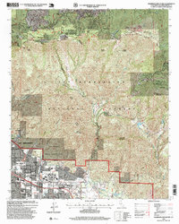
1996 Map of Harrison Mountain
USGS Topo · Published 1999About this map
The transition from the urban sprawl of San Bernardino to the high elevations of the San Bernardino National Forest is clearly delineated in this late-1990s revision. At the base of the mountains, the grounds of Patton State Hospital and the residential neighborhoods of Highland and Del Rosa sit just south of the San Manuel Indian Reservation. As the elevation rises toward the Rim of the World Scenic Byway, the landscape shifts into a cluster of mountain communities including Twin Peaks, Blue Jay, and Lake Arrowhead. This topographic study reveals the dense network of canyons, such as City Creek Canyon, that separate the valley floor from the summit resort towns and the sprawling forest lands to the north. These features illustrate the mid-century development of the Inland Empire and its relationship with the surrounding natural landmarks like McKinley Mountain and Harrison Mountain.
Find a feature on this map
35 named features on this map. Tap any name to fly to it.
Don’t see what you’re looking for? This feature index may not catch every label — zoom into the map to look around manually.
Map Details
Editions of this 1996 Harrison Mountain Map
This is the sole edition of this map. No revisions or reprints were ever made.
Other maps of this area

1896 · San Bernardino
USGS Topo · 1:62,500

1898 · San Bernardino
USGS Topo · 1:62,500

1899 · Redlands
USGS Topo · 1:62,500

1901 · Southern California Sheet No. 1
USGS Topo · 1:250,000

1901 · San Bernardino
USGS Topo · 1:62,500

1901 · Redlands
USGS Topo · 1:62,500

1902 · Deep Creek
USGS Topo · 1:62,500

1902 · Hesperia
USGS Topo · 1:62,500

1904 · Southern California Sheet No. 1
USGS Topo · 1:250,000

1936 · Arrowhead
USGS Topo · 1:31,680