1940s Maps of Vidal Junction, California
Explore 2 historic maps of Vidal Junction from the 1940s. These maps offer a rare glimpse into what life looked like during the 1940s — showing old roads, neighborhoods, homes, and landmarks that have changed or disappeared over time.
Whether you're researching your family's past, planning a metal detecting trip, or studying how Vidal Junction's landscape evolved across the 1940s, these high-resolution maps are a powerful tool for exploring the history of this region.
- Focus on a specific era: All maps on this page are from the 1940s, giving you a focused view of this time period.
- See what’s changed: Compare century-old streets, trails, and buildings to today's modern landscape using overlays and satellite layers.
- Research with precision: Use these maps for genealogy, historical research, land use analysis, or educational projects.
- View, download, or print: Maps are fully viewable online in high resolution, and can be downloaded or printed for your own records.
Start exploring Vidal Junction's history through authentic maps from the 1940s. This is your window into the past.
Vidal Junction, CA maps
(2)- 1943 Map of Vidal, 1944 Print
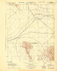 1943 Vidal1944 Print · USGSThe eastern Mojave Desert is captured here during the Second World War as a vital military maneuver area. Researchers can trace the infrastructure of the Metropolitan Water District Aqueduct and early desert outposts like Grommet and Vidal.
 - 1949 Map of Vidal, 1963 Print
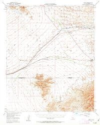 1949 Vidal1963 Print · USGSThe California desert comes alive mid-century as a hub for rail transit and mountain mining. Trace the Atchison Topeka and Santa Fe rail line through Vidal and Grommet, or locate remote desert workings like the Gold Rice Mine.2 unique versions available
End of results
Showing maps 1-2 of 2
Top cities near Vidal Junction
Frequently asked questions
- What are the different types of historical maps available for Vidal Junction?
- What is the oldest map of Vidal Junction?
- Where can I purchase historical maps of Vidal Junction for my home or office?
- Where can I download high-res historical maps of Vidal Junction?
- Are there historical topographic maps available for Vidal Junction?
- Is there historical aerial imagery available for Vidal Junction?
- Where are historical maps of Vidal Junction sourced from?