1980s Maps of Yucca Grove, California
Explore 2 historic maps of Yucca Grove from the 1980s. These maps offer a rare glimpse into what life looked like during the 1980s — showing old roads, neighborhoods, homes, and landmarks that have changed or disappeared over time.
Whether you're researching your family's past, planning a metal detecting trip, or studying how Yucca Grove's landscape evolved across the 1980s, these high-resolution maps are a powerful tool for exploring the history of this region.
- Focus on a specific era: All maps on this page are from the 1980s, giving you a focused view of this time period.
- See what’s changed: Compare century-old streets, trails, and buildings to today's modern landscape using overlays and satellite layers.
- Research with precision: Use these maps for genealogy, historical research, land use analysis, or educational projects.
- View, download, or print: Maps are fully viewable online in high resolution, and can be downloaded or printed for your own records.
Start exploring Yucca Grove's history through authentic maps from the 1980s. This is your window into the past.
Yucca Grove, CA maps
(2)- 1983 Map of Solomons Knob
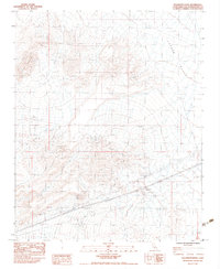 1983 Solomons Knob1983 Print · USGSSan Bernardino County's high desert reaches are captured here in the early eighties, showing a landscape shaped by mining and rugged terrain. Researchers can locate remote sites like the Great Whamingo Mine, Telegraph Mine, and water sources at Francis Spring.2 unique versions available
 - 1985 Map of Ivanpah
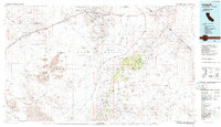 1985 Ivanpah1985 Print · USGSThe high desert of San Bernardino County is shown here in the mid-eighties, centered on the newly designated East Mojave National Scenic Area. Researchers can trace the Union Pacific rail line through remote stops like Kelso and Cima or locate historic extraction sites like the Morning Star Mine.2 unique versions available
End of results
Showing maps 1-2 of 2
Top cities near Yucca Grove
Frequently asked questions
- What are the different types of historical maps available for Yucca Grove?
- What is the oldest map of Yucca Grove?
- Where can I purchase historical maps of Yucca Grove for my home or office?
- Where can I download high-res historical maps of Yucca Grove?
- Are there historical topographic maps available for Yucca Grove?
- Is there historical aerial imagery available for Yucca Grove?
- Where are historical maps of Yucca Grove sourced from?