1940s Maps of Borrego Springs, California
Explore 6 historic maps of Borrego Springs from the 1940s. These maps offer a rare glimpse into what life looked like during the 1940s — showing old roads, neighborhoods, homes, and landmarks that have changed or disappeared over time.
Whether you're researching your family's past, planning a metal detecting trip, or studying how Borrego Springs's landscape evolved across the 1940s, these high-resolution maps are a powerful tool for exploring the history of this region.
- Focus on a specific era: All maps on this page are from the 1940s, giving you a focused view of this time period.
- See what’s changed: Compare century-old streets, trails, and buildings to today's modern landscape using overlays and satellite layers.
- Research with precision: Use these maps for genealogy, historical research, land use analysis, or educational projects.
- View, download, or print: Maps are fully viewable online in high resolution, and can be downloaded or printed for your own records.
Start exploring Borrego Springs's history through authentic maps from the 1940s. This is your window into the past.
Borrego Springs, CA maps
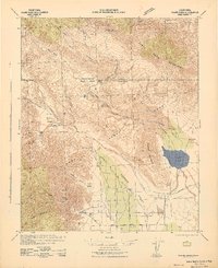
(6)- 1941 Map of Clark Lake, 1956 Print
 1941 Clark Lake1956 Print · USGSBorrego Valley and the Santa Rosa Mountains are captured here in the early 1940s, showing a desert landscape before modern development. You can trace the early ranching history of the region through markers like Rancho De Anza, Brinniger Ranch, and the Anza Trail.
 - 1942 Map of Clark Lake
 1942 Clark Lake1942 Print · USGSSan Diego and Riverside Counties were still largely defined by remote ranching and desert springs during the early 1940s. Genealogists and historians can trace the foundations of the valley at Brinniger Ranch, the Borrego Sch, and the Old Santa Rosa Indian Ruins.2 unique versions available
 - 1943 Map of Vallecito
 1943 Vallecito1943 Print · USGSThe Colorado Desert during the early 1940s is captured here, showing the remote ranching outposts and new state park boundaries. Genealogists can trace family holdings like Oliver Ranch and Rancho De Anza or locate historic sites such as Borrego School and the Gypsum Mine.
 - 1947 Map of Santa Ana, 1949 Print
 1947 Santa Ana1949 Print · USGSSouthern California is depicted here in the late forties, showing the expansion of the Inland Empire and the Orange County coast. Researchers can trace the early layout of Palm Springs or locate long-standing tribal lands like the Pala Indian Reservation and Rincon Indian Res.
 - 1947 Map of Clark Lake, 1952 Print
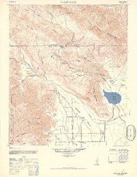 1947 Clark Lake1952 Print · USGSBorego Valley and the surrounding mountains show a transition from ancient sites to mid-century ranching during the late 1940s. Genealogists and researchers can locate the Old Santa Rosa Indian Ruins, the Brinniger Ranch, and the original Borego School.2 unique versions available
 - 1949 Map of Santa Ana
 1949 Santa Ana1949 Print · USGSSouthern California underwent a profound transformation in the late 1940s as military installations and citrus groves shared the landscape. Researchers can trace early coastal growth at Laguna Beach, military history at Camp Pendleton, and the rail corridors of the Pacific Electric.
End of results
Showing maps 1-6 of 6
Top cities near Borrego Springs
Frequently asked questions
- What are the different types of historical maps available for Borrego Springs?
- What is the oldest map of Borrego Springs?
- Where can I purchase historical maps of Borrego Springs for my home or office?
- Where can I download high-res historical maps of Borrego Springs?
- Are there historical topographic maps available for Borrego Springs?
- Is there historical aerial imagery available for Borrego Springs?
- Where are historical maps of Borrego Springs sourced from?