1990s Maps of Carlsbad, California
Explore 5 historic maps of Carlsbad from the 1990s. These maps offer a rare glimpse into what life looked like during the 1990s — showing old roads, neighborhoods, homes, and landmarks that have changed or disappeared over time.
Whether you're researching your family's past, planning a metal detecting trip, or studying how Carlsbad's landscape evolved across the 1990s, these high-resolution maps are a powerful tool for exploring the history of this region.
- Focus on a specific era: All maps on this page are from the 1990s, giving you a focused view of this time period.
- See what’s changed: Compare century-old streets, trails, and buildings to today's modern landscape using overlays and satellite layers.
- Research with precision: Use these maps for genealogy, historical research, land use analysis, or educational projects.
- View, download, or print: Maps are fully viewable online in high resolution, and can be downloaded or printed for your own records.
Start exploring Carlsbad's history through authentic maps from the 1990s. This is your window into the past.
Carlsbad, CA maps
(5)- 1996 Map of San Marcos, 2000 Print
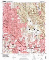 1996 San Marcos2000 Print · USGSSan Diego County's inland corridor shows rapid development during the late nineties as the cities of San Marcos and Vista expand into the surrounding foothills. Researchers can trace the layout of local neighborhoods and schools like Palomar College and San Marcos High Sch alongside the historic Oceanside and Escondido rail route.
 - 1996 Map of Rancho Santa Fe, 2001 Print
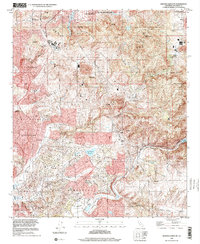 1996 Rancho Santa Fe2001 Print · USGSCoastal San Diego County is captured here in the late nineties as residential development and regional water management reshaped the canyon lands. Trace family roots and land patterns near Rancho Santa Fe, the historical Olivenhain settlement, and Lake Hodges.
 - 1997 Map of San Luis Rey, 2000 Print
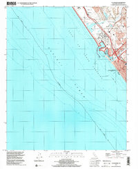
 1997 San Luis Rey2000 Print · USGSThe North County coastline in the late nineties shows a rapidly growing suburban corridor between the Pacific and inland peaks. Trace the grounds of the Mission San Luis Rey de Francia and identify local landmarks like the Oceanside Municipal Airport or Calavera Lake.
 - 1997 Map of Oceanside, 2000 Print
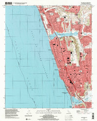
 1997 Oceanside2000 Print · USGSThe coastal interface of North County San Diego appears here during the late nineties as a blend of military operations and growing residential neighborhoods. Researchers can trace the layout of Camp Pendleton, the development of Oceanside Harbor, and local landmarks like Santa Margarita Sch.
 - 1997 Map of Encinitas, 2001 Print
 1997 Encinitas2001 Print · USGSThe San Diego coast at the close of the century shows the dense residential growth of Encinitas and Carlsbad around vital estuaries. Trace local genealogy and civic history through sites like San Dieguito Union High Sch, the Santa Fe railway, and Batiquitos Lagoon.
End of results
Showing maps 1-5 of 5
Top cities near Carlsbad
- San Diego historical maps
- Oceanside historical maps
- Escondido historical maps
- Vista historical maps
- San Marcos historical maps
- Encinitas historical maps
See more
Top neighborhoods of Carlsbad
- Calavera historical maps
- Bressi Ranch historical maps
- Aviara historical maps
- Poinsettia historical maps
- Safety Center historical maps
- Robertson Ranch historical maps
See more
Frequently asked questions
- What are the different types of historical maps available for Carlsbad?
- What is the oldest map of Carlsbad?
- Where can I purchase historical maps of Carlsbad for my home or office?
- Where can I download high-res historical maps of Carlsbad?
- Are there historical topographic maps available for Carlsbad?
- Is there historical aerial imagery available for Carlsbad?
- Where are historical maps of Carlsbad sourced from?