1940s Maps of Descanso Junction, California
Explore 2 historic maps of Descanso Junction from the 1940s. These maps offer a rare glimpse into what life looked like during the 1940s — showing old roads, neighborhoods, homes, and landmarks that have changed or disappeared over time.
Whether you're researching your family's past, planning a metal detecting trip, or studying how Descanso Junction's landscape evolved across the 1940s, these high-resolution maps are a powerful tool for exploring the history of this region.
- Focus on a specific era: All maps on this page are from the 1940s, giving you a focused view of this time period.
- See what’s changed: Compare century-old streets, trails, and buildings to today's modern landscape using overlays and satellite layers.
- Research with precision: Use these maps for genealogy, historical research, land use analysis, or educational projects.
- View, download, or print: Maps are fully viewable online in high resolution, and can be downloaded or printed for your own records.
Start exploring Descanso Junction's history through authentic maps from the 1940s. This is your window into the past.
Descanso Junction, CA maps
(2)- 1942 Map of Cuyamaca Peak, 1954 Print
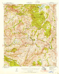 1942 Cuyamaca Peak1954 Print · USGSSan Diego County’s backcountry comes alive in the early 1940s, showing the high mountain ranching and reservation lands before modern development. Researchers can trace the footprints of Anahuac Sch, Burney Ranch, and the Viejas Indian Reservation.2 unique versions available
 - 1944 Map of Cuyamaca Peak
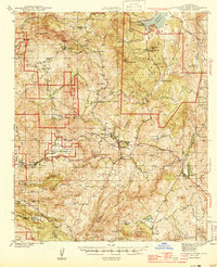 1944 Cuyamaca Peak1944 Print · USGSSan Diego’s high country in the early 1940s is shown as a network of cattle ranches and mountain settlements. Researchers can locate early schools and family landmarks like Anahuac Sch, Burney Ranch, and the Cuyamaca Lodge.2 unique versions available
End of results
Showing maps 1-2 of 2
Top cities near Descanso Junction
- Alpine historical maps
- San Diego Country Estates historical maps
- Harbison Canyon historical maps
- Julian historical maps
- Pine Valley historical maps
- Descanso historical maps
See more
Frequently asked questions
- What are the different types of historical maps available for Descanso Junction?
- What is the oldest map of Descanso Junction?
- Where can I purchase historical maps of Descanso Junction for my home or office?
- Where can I download high-res historical maps of Descanso Junction?
- Are there historical topographic maps available for Descanso Junction?
- Is there historical aerial imagery available for Descanso Junction?
- Where are historical maps of Descanso Junction sourced from?