1970s Maps of El Cajon, California
Explore 2 historic maps of El Cajon from the 1970s. These maps offer a rare glimpse into what life looked like during the 1970s — showing old roads, neighborhoods, homes, and landmarks that have changed or disappeared over time.
Whether you're researching your family's past, planning a metal detecting trip, or studying how El Cajon's landscape evolved across the 1970s, these high-resolution maps are a powerful tool for exploring the history of this region.
- Focus on a specific era: All maps on this page are from the 1970s, giving you a focused view of this time period.
- See what’s changed: Compare century-old streets, trails, and buildings to today's modern landscape using overlays and satellite layers.
- Research with precision: Use these maps for genealogy, historical research, land use analysis, or educational projects.
- View, download, or print: Maps are fully viewable online in high resolution, and can be downloaded or printed for your own records.
Start exploring El Cajon's history through authentic maps from the 1970s. This is your window into the past.
El Cajon, CA maps
(2)- 1979 Map of El Cajon
 1979 El Cajon1979 Print · USGSSouthern San Diego County and its mountain-to-desert transition are captured here in the late seventies. Researchers can trace the winding San Diego & Arizona Eastern RR, locate rural settlements like Jacumba, and explore the sprawling Cleveland National Forest.2 unique versions available
 - 1979 Map of San Diego, 1980 Print
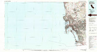 1979 San Diego1980 Print · USGSSan Diego and the southern California coastline are shown in the late seventies as the region's modern layout became firmly established. Researchers can trace the extensive military footprint at Miramar and find local landmarks from Cabrillo National Monument to Mission Bay Park.3 unique versions available
End of results
Showing maps 1-2 of 2
Top cities near El Cajon
- San Diego historical maps
- Chula Vista historical maps
- La Mesa historical maps
- Santee historical maps
- National City historical maps
- Poway historical maps
See more
Top neighborhoods of El Cajon
- Fletcher Hills historical maps
- Hillsdale historical maps
- Cajon Heights historical maps
- Bostonia historical maps
Frequently asked questions
- What are the different types of historical maps available for El Cajon?
- What is the oldest map of El Cajon?
- Where can I purchase historical maps of El Cajon for my home or office?
- Where can I download high-res historical maps of El Cajon?
- Are there historical topographic maps available for El Cajon?
- Is there historical aerial imagery available for El Cajon?
- Where are historical maps of El Cajon sourced from?