1960s Maps of Los Terrenitos, California
Explore 2 historic maps of Los Terrenitos from the 1960s. These maps offer a rare glimpse into what life looked like during the 1960s — showing old roads, neighborhoods, homes, and landmarks that have changed or disappeared over time.
Whether you're researching your family's past, planning a metal detecting trip, or studying how Los Terrenitos's landscape evolved across the 1960s, these high-resolution maps are a powerful tool for exploring the history of this region.
- Focus on a specific era: All maps on this page are from the 1960s, giving you a focused view of this time period.
- See what’s changed: Compare century-old streets, trails, and buildings to today's modern landscape using overlays and satellite layers.
- Research with precision: Use these maps for genealogy, historical research, land use analysis, or educational projects.
- View, download, or print: Maps are fully viewable online in high resolution, and can be downloaded or printed for your own records.
Start exploring Los Terrenitos's history through authentic maps from the 1960s. This is your window into the past.
Los Terrenitos, CA maps
(2)- 1960 Map of Descanso, 1961 Print
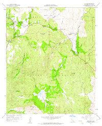 1960 Descanso1961 Print · USGSSan Diego's high country during the early sixties shows a landscape defined by mountain camps and winding forest roads. Genealogists and historians can trace old homesteads and recreational sites from Hulburd Grove to the Pine Creek Bible Conference Ground.6 unique versions available
 - 1960 Map of Cuyamaca Peak, 1962 Print
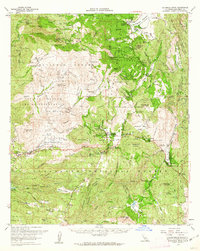 1960 Cuyamaca Peak1962 Print · USGSThe San Diego backcountry comes into focus in the early sixties, showing the mountain communities and expansive parklands of the Cuyamaca region. Genealogists and hikers can trace old homesteads like Burney Ranch and historical sites such as Stonewall Mine or the Cuyamaca Lodge.2 unique versions available
End of results
Showing maps 1-2 of 2
Top cities near Los Terrenitos
- Alpine historical maps
- San Diego Country Estates historical maps
- Harbison Canyon historical maps
- Campo historical maps
- Julian historical maps
- Pine Valley historical maps
See more
Frequently asked questions
- What are the different types of historical maps available for Los Terrenitos?
- What is the oldest map of Los Terrenitos?
- Where can I purchase historical maps of Los Terrenitos for my home or office?
- Where can I download high-res historical maps of Los Terrenitos?
- Are there historical topographic maps available for Los Terrenitos?
- Is there historical aerial imagery available for Los Terrenitos?
- Where are historical maps of Los Terrenitos sourced from?