1960s Maps of Oceanside, California
Explore 7 historic maps of Oceanside from the 1960s. These maps offer a rare glimpse into what life looked like during the 1960s — showing old roads, neighborhoods, homes, and landmarks that have changed or disappeared over time.
Whether you're researching your family's past, planning a metal detecting trip, or studying how Oceanside's landscape evolved across the 1960s, these high-resolution maps are a powerful tool for exploring the history of this region.
- Focus on a specific era: All maps on this page are from the 1960s, giving you a focused view of this time period.
- See what’s changed: Compare century-old streets, trails, and buildings to today's modern landscape using overlays and satellite layers.
- Research with precision: Use these maps for genealogy, historical research, land use analysis, or educational projects.
- View, download, or print: Maps are fully viewable online in high resolution, and can be downloaded or printed for your own records.
Start exploring Oceanside's history through authentic maps from the 1960s. This is your window into the past.
Oceanside, CA maps
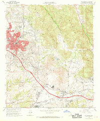
(7)- 1960 Map of Santa Ana
 1960 Santa Ana1960 Print · USGSSouthern California's coastal plains and inland deserts meet in this mid-century survey of the burgeoning Orange and Riverside county corridors. Researchers can trace the layout of early freeway systems, find tribal lands like the Soboba Indian Reservation, and locate military landmarks such as March Field.2 unique versions available
 - 1965 Map of Santa Ana
 1965 Santa Ana1965 Print · USGSSouthern California is captured in a decade of rapid growth, showing the coastal expansion from Santa Ana down to Oceanside. Genealogists and historians can trace the mid-century development of places like Garden Grove or the rural reaches of Escondido and the Palomar Observatory.
 - 1968 Map of San Luis Rey, 1969 Print
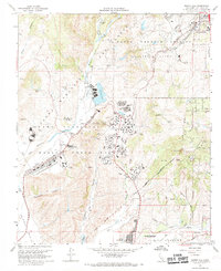
 1968 San Luis Rey1969 Print · USGSCoastal San Diego County enters a period of rapid mid-century expansion between the late 1940s and late 1960s. Genealogists and historians can trace institutional landmarks like Mission San Luis Rey de Francia, the Army and Navy Academy, and the Oceanside Airport.3 unique versions available
 - 1968 Map of Morro Hill, 1969 Print
 1968 Morro Hill1969 Print · USGSThe northern reaches of San Diego County are captured here in the late sixties, showcasing the vast military infrastructure of Camp Pendleton. Genealogists and local historians can trace the rail lines of the Atchison Topeka and Santa Fe or locate landmarks like Pendleton School and the Home Ranch.3 unique versions available
 - 1968 Map of San Marcos, 1970 Print
 1968 San Marcos1970 Print · USGSSan Diego County is shown in a period of suburban transformation during the late sixties as the inland valleys between the coast and the mountains began to fill. Researchers can trace the development of early educational campuses like Palomar College and Vista High School, alongside historic landmarks such as the San Marcos Cemetery and the Atchison Topeka and Santa Fe rail line.3 unique versions available
 - 1968 Map of Bonsall, 1970 Print
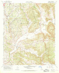 1968 Bonsall1970 Print · USGSBonsall and the surrounding hills of San Diego County are captured here in the late sixties as the area transitioned from rural ranchland to a suburban and recreational hub. Researchers can trace the layout of Fallbrook and San Luis Rey Heights alongside family landmarks like the Dulin Ranch and the Fallbrook Community Air Park.3 unique versions available
 - 1968 Map of Oceanside, 1970 Print
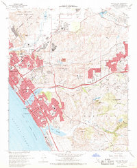
 1968 Oceanside1970 Print · USGSCoastal San Diego County comes into focus in the late sixties as military and civilian life intersect along the Pacific. Researchers can trace the layout of Camp Pendleton Marine Corps Base, locate the historic Mission San Luis Rey, and see the mid-century waterfront at Oceanside Pier.2 unique versions available
End of results
Showing maps 1-7 of 7
Top cities near Oceanside
- San Diego historical maps
- Escondido historical maps
- Carlsbad historical maps
- Temecula historical maps
- Vista historical maps
- San Marcos historical maps
See more
Top neighborhoods of Oceanside
- Escondido Junction historical maps
- South Oceanside historical maps
- Talich historical maps
- Ocean Hills historical maps
- Oceana historical maps
- San Luis Rey historical maps
Frequently asked questions
- What are the different types of historical maps available for Oceanside?
- What is the oldest map of Oceanside?
- Where can I purchase historical maps of Oceanside for my home or office?
- Where can I download high-res historical maps of Oceanside?
- Are there historical topographic maps available for Oceanside?
- Is there historical aerial imagery available for Oceanside?
- Where are historical maps of Oceanside sourced from?