1960s Maps of Ocotillo Wells, California
Explore 4 historic maps of Ocotillo Wells from the 1960s. These maps offer a rare glimpse into what life looked like during the 1960s — showing old roads, neighborhoods, homes, and landmarks that have changed or disappeared over time.
Whether you're researching your family's past, planning a metal detecting trip, or studying how Ocotillo Wells's landscape evolved across the 1960s, these high-resolution maps are a powerful tool for exploring the history of this region.
- Focus on a specific era: All maps on this page are from the 1960s, giving you a focused view of this time period.
- See what’s changed: Compare century-old streets, trails, and buildings to today's modern landscape using overlays and satellite layers.
- Research with precision: Use these maps for genealogy, historical research, land use analysis, or educational projects.
- View, download, or print: Maps are fully viewable online in high resolution, and can be downloaded or printed for your own records.
Start exploring Ocotillo Wells's history through authentic maps from the 1960s. This is your window into the past.
Ocotillo Wells, CA maps
(4)- 1960 Map of Santa Ana
 1960 Santa Ana1960 Print · USGSSouthern California's coastal plains and inland deserts meet in this mid-century survey of the burgeoning Orange and Riverside county corridors. Researchers can trace the layout of early freeway systems, find tribal lands like the Soboba Indian Reservation, and locate military landmarks such as March Field.2 unique versions available
 - 1960 Map of Borrego Mountain, 1961 Print
 1960 Borrego Mountain1961 Print · USGSThe Colorado Desert during the early sixties reveals a landscape of remote outposts and shifting sands within the Anza-Borrego Desert State Park. Traces of local history are preserved at the Little Borrego (Site), the USN Railroad, and the Elephant Tree Area.2 unique versions available
 - 1960 Map of Borrego Mountain, 1961 Print
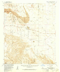
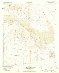 1960 Borrego Mountain1961 Print · USGSSan Diego County's desert interior is captured in the early sixties as a playground for geology and exploration. Trace the early layout of Ocotillo Wells and navigate the primitive routes of Old Kane Spring Road and The Slot.4 unique versions available
 - 1965 Map of Santa Ana
 1965 Santa Ana1965 Print · USGSSouthern California is captured in a decade of rapid growth, showing the coastal expansion from Santa Ana down to Oceanside. Genealogists and historians can trace the mid-century development of places like Garden Grove or the rural reaches of Escondido and the Palomar Observatory.
End of results
Showing maps 1-4 of 4
Top cities near Ocotillo Wells
Frequently asked questions
- What are the different types of historical maps available for Ocotillo Wells?
- What is the oldest map of Ocotillo Wells?
- Where can I purchase historical maps of Ocotillo Wells for my home or office?
- Where can I download high-res historical maps of Ocotillo Wells?
- Are there historical topographic maps available for Ocotillo Wells?
- Is there historical aerial imagery available for Ocotillo Wells?
- Where are historical maps of Ocotillo Wells sourced from?