1990s Maps of San Diego Country Estates, California
Explore 3 historic maps of San Diego Country Estates from the 1990s. These maps offer a rare glimpse into what life looked like during the 1990s — showing old roads, neighborhoods, homes, and landmarks that have changed or disappeared over time.
Whether you're researching your family's past, planning a metal detecting trip, or studying how San Diego Country Estates's landscape evolved across the 1990s, these high-resolution maps are a powerful tool for exploring the history of this region.
- Focus on a specific era: All maps on this page are from the 1990s, giving you a focused view of this time period.
- See what’s changed: Compare century-old streets, trails, and buildings to today's modern landscape using overlays and satellite layers.
- Research with precision: Use these maps for genealogy, historical research, land use analysis, or educational projects.
- View, download, or print: Maps are fully viewable online in high resolution, and can be downloaded or printed for your own records.
Start exploring San Diego Country Estates's history through authentic maps from the 1990s. This is your window into the past.
San Diego Country Estates, CA maps
(3)- 1997 Map of Ramona, 2000 Print
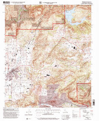 1997 Ramona2000 Print · USGSRamona and the surrounding San Diego back-country are captured in the late nineties as residential growth meets ancient land grants. Researchers can trace the layout of the Santa Maria Grant or locate the Bassett Ranch, Union High School, and local Cemeteries.
 - 1997 Map of El Cajon Mountain, 2000 Print
 1997 El Cajon Mountain2000 Print · USGSSan Diego County’s rugged interior is captured here in the late nineties as tribal lands meet the national forest. Researchers can locate family landmarks like Poole Ranch and Grable Ranch or trace the early footprint of the El Capitan Reservoir.
 - 1997 Map of Santa Ysabel, 2000 Print
 1997 Santa Ysabel2000 Print · USGSSan Diego's high country is captured here in the late nineties, documenting the rugged intersection of ranch lands and national forest. Genealogists and hikers can locate the Santa Ysabel Sch, the Old Virginia Mine, and the Quanai National Recreation Trail.
End of results
Showing maps 1-3 of 3
Top cities near San Diego Country Estates
- San Diego historical maps
- Escondido historical maps
- El Cajon historical maps
- La Mesa historical maps
- Santee historical maps
- Poway historical maps
See more
Frequently asked questions
- What are the different types of historical maps available for San Diego Country Estates?
- What is the oldest map of San Diego Country Estates?
- Where can I purchase historical maps of San Diego Country Estates for my home or office?
- Where can I download high-res historical maps of San Diego Country Estates?
- Are there historical topographic maps available for San Diego Country Estates?
- Is there historical aerial imagery available for San Diego Country Estates?
- Where are historical maps of San Diego Country Estates sourced from?