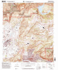
1997 Map of Ramona
USGS Topo · Published 2000About this map
The Santa Maria Grant and the settlement of Ramona dominate this late 20th-century landscape, illustrating the complex overlap of Spanish-era land grants and modern development. This territory is characterized by a series of narrow valleys including Santa Teresa Valley and Ballena Valley, separated by significant heights like Whale Mountain and Mount Gower. To the north, the waters of Sutherland Lake are managed via a Gaging Station and Spillway 2068 on Santa Ysabel Creek.
Find a feature on this map
31 named features on this map. Tap any name to fly to it.
Don’t see what you’re looking for? This feature index may not catch every label — zoom into the map to look around manually.
Map Details
Editions of this 1997 Ramona Map
This is the sole edition of this map. No revisions or reprints were ever made.
Other maps of this area

1893 · El Cajon
USGS Topo · 1:62,500

1901 · Elcajon
USGS Topo · 1:62,500

1903 · Cuyamaca
USGS Topo · 1:125,000

1903 · Elcajon
USGS Topo · 1:62,500

1903 · Ramona
USGS Topo · 1:125,000

1904 · Southern California Sheet No. 2
USGS Topo · 1:250,000

1939 · El Cajon
USGS Topo · 1:62,500

1939 · Santa Ysabel
USGS Topo · 1:62,500

1942 · El Cajon
USGS Topo · 1:62,500

1942 · Ramona
USGS Topo · 1:62,500