
1942 Map of Ramona
USGS Topo · Published 1947About this map
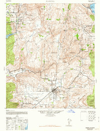
The settlement of Ramona occupies a central valley position on this 1947 reprint of an Army Map Service survey, surrounded by the foothills and peaks of the Cleveland National Forest. The landscape is a patchwork of agricultural valleys and protected lands, including the San Pasqual Indian Reservation and Mesa Grande Ind Res. Regional hydrology is anchored by major water bodies like Lake Wohlford and Lake Henshaw, with Santa Maria Creek winding through the lowlands. The presence of several outlying properties such as Vineyard Ranch and Silvano Ranch suggests a rural economy built on ranching and cultivation in the early 1940s. Transportation follows the natural contours of the San Pasqual Valley and Pamo Valley, connecting these isolated agricultural pockets. Historical landmarks like the Ramona Guard Station and Pamo Ranger Station highlight the importance of forest management and fire observation in this chaparral-covered terrain during the mid-twentieth century.
Find a feature on this map
42 named features on this map. Tap any name to fly to it.
Don’t see what you’re looking for? This feature index may not catch every label — zoom into the map to look around manually.
Map Details
Editions of this 1942 Ramona Map
2 editions found
Other maps of this area

1893 · El Cajon
USGS Topo · 1:62,500

1893 · Escondido
USGS Topo · 1:62,500

1901 · Elcajon
USGS Topo · 1:62,500

1901 · Escondido
USGS Topo · 1:62,500

1901 · San Luis Rey
USGS Topo · 1:125,000

1903 · Cuyamaca
USGS Topo · 1:125,000

1903 · La Jolla
USGS Topo · 1:62,500

1903 · Elcajon
USGS Topo · 1:62,500

1903 · Ramona
USGS Topo · 1:125,000

1904 · Southern California Sheet No. 2
USGS Topo · 1:250,000