
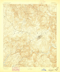
1893 Map of Escondido
USGS Topo · Published 1893About this map
Escondido sits as the central hub of this North County landscape, depicted shortly after its late-19th-century incorporation. The city's grid is established adjacent to the California Southern Railroad, which winds through the San Marcos Mountains to connect inland valleys with the coast. This period of development is marked by small agricultural outposts and early ranching centers like San Marcos, Richland, and Twin Oaks.
Find a feature on this map
37 named features on this map. Tap any name to fly to it.
Don’t see what you’re looking for? This feature index may not catch every label — zoom into the map to look around manually.
Map Details
Editions of this 1893 Escondido Map
2 editions found
Other maps of this area

1893 · El Cajon
USGS Topo · 1:62,500

1893 · Oceanside
USGS Topo · 1:62,500

1898 · Oceanside
USGS Topo · 1:62,500

1901 · Elcajon
USGS Topo · 1:62,500

1901 · Escondido
USGS Topo · 1:62,500

1901 · Oceanside
USGS Topo · 1:62,500

1901 · San Luis Rey
USGS Topo · 1:125,000

1903 · Cuyamaca
USGS Topo · 1:125,000

1903 · La Jolla
USGS Topo · 1:62,500

1903 · Elcajon
USGS Topo · 1:62,500