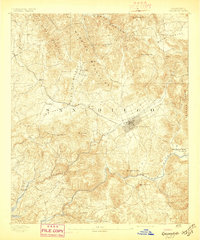
1893 Map of Escondido
USGS Topo · Published 1897About this map
The Escondido townsite serves as the focal point of this inland San Diego County survey, appearing as a developed grid at the terminus of a spur from the Southern California Railroad. This late-nineteenth-century landscape is defined by its transition from high mountain ridges like the San Marcos Mountains and Merriam Mountains into the agricultural potential of Bear Valley and the San Pascual Valley. The settlement pattern follows the drainage of the Bernardo River and its tributaries, with early communities such as San Marcos, Vista, and the German colony of Olivenhain established near these essential water sources. Geographic landmarks like Mt. Whitney (a local summit) and Battle Mountain provide clear reference points for the varied terrain. Smaller rural centers including Richland, Twin Oaks, and Bernardo illustrate the early distribution of ranching and farming outposts before the major urban expansion of the following century.
Find a feature on this map
36 named features on this map. Tap any name to fly to it.
Don’t see what you’re looking for? This feature index may not catch every label — zoom into the map to look around manually.
Map Details
Editions of this 1893 Escondido Map
2 editions found
Other maps of this area

1893 · El Cajon
USGS Topo · 1:62,500

1893 · Oceanside
USGS Topo · 1:62,500

1893 · Escondido
USGS Topo · 1:62,500

1898 · Oceanside
USGS Topo · 1:62,500

1901 · Elcajon
USGS Topo · 1:62,500

1901 · Escondido
USGS Topo · 1:62,500

1901 · Oceanside
USGS Topo · 1:62,500

1901 · San Luis Rey
USGS Topo · 1:125,000

1903 · Cuyamaca
USGS Topo · 1:125,000

1903 · La Jolla
USGS Topo · 1:62,500