1960s Maps of Lodi, California
Explore 4 historic maps of Lodi from the 1960s. These maps offer a rare glimpse into what life looked like during the 1960s — showing old roads, neighborhoods, homes, and landmarks that have changed or disappeared over time.
Whether you're researching your family's past, planning a metal detecting trip, or studying how Lodi's landscape evolved across the 1960s, these high-resolution maps are a powerful tool for exploring the history of this region.
- Focus on a specific era: All maps on this page are from the 1960s, giving you a focused view of this time period.
- See what’s changed: Compare century-old streets, trails, and buildings to today's modern landscape using overlays and satellite layers.
- Research with precision: Use these maps for genealogy, historical research, land use analysis, or educational projects.
- View, download, or print: Maps are fully viewable online in high resolution, and can be downloaded or printed for your own records.
Start exploring Lodi's history through authentic maps from the 1960s. This is your window into the past.
Lodi, CA maps
(4)- 1968 Map of Lodi North, 1972 Print
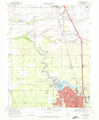 1968 Lodi North1972 Print · USGSSan Joaquin County agriculture and the city of Lodi thrive in the late sixties as the region's rail and irrigation networks reach full maturity. Researchers can locate vanished rural landmarks and family sites like Houston School, Liberty Cemetery, and Linds Airport.2 unique versions available
 - 1968 Map of Lodi South, 1972 Print
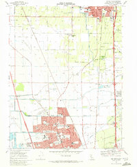 1968 Lodi South1972 Print · USGSThe agricultural heart of San Joaquin County is captured here in the late sixties as suburban expansion reaches northward from Stockton. Trace family roots and local history through features like Lodi Academy, Henderson Village, and the Micke Grove County Park.3 unique versions available
 - 1968 Map of Waterloo, 1972 Print
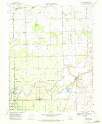
 1968 Waterloo1972 Print · USGSSan Joaquin County agriculture and water infrastructure are in focus here during the late sixties. Researchers can trace rural school locations like Waterloo Sch and the Jack Tone Homestead Historical Marker near the Mokelumne Aqueduct.3 unique versions available
 - 1968 Map of Lockeford, 1972 Print
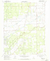
 1968 Lockeford1972 Print · USGSSan Joaquin County agriculture is in full bloom in the late sixties, centered on the vital corridor of the Mokelumne River. Researchers can trace the rail-and-river economy through the streets of Lockeford, locating Locke Cem and old school sites like Bruella Sch.3 unique versions available
End of results
Showing maps 1-4 of 4
Top cities near Lodi
Top neighborhoods of Lodi
Frequently asked questions
- What are the different types of historical maps available for Lodi?
- What is the oldest map of Lodi?
- Where can I purchase historical maps of Lodi for my home or office?
- Where can I download high-res historical maps of Lodi?
- Are there historical topographic maps available for Lodi?
- Is there historical aerial imagery available for Lodi?
- Where are historical maps of Lodi sourced from?