1960s Maps of Atascadero, California
Explore 3 historic maps of Atascadero from the 1960s. These maps offer a rare glimpse into what life looked like during the 1960s — showing old roads, neighborhoods, homes, and landmarks that have changed or disappeared over time.
Whether you're researching your family's past, planning a metal detecting trip, or studying how Atascadero's landscape evolved across the 1960s, these high-resolution maps are a powerful tool for exploring the history of this region.
- Focus on a specific era: All maps on this page are from the 1960s, giving you a focused view of this time period.
- See what’s changed: Compare century-old streets, trails, and buildings to today's modern landscape using overlays and satellite layers.
- Research with precision: Use these maps for genealogy, historical research, land use analysis, or educational projects.
- View, download, or print: Maps are fully viewable online in high resolution, and can be downloaded or printed for your own records.
Start exploring Atascadero's history through authentic maps from the 1960s. This is your window into the past.
Atascadero, CA maps
(3)- 1961 Map of Paso Robles, 1968 Print
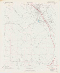
 1961 Paso Robles1968 Print · USGSSan Luis Obispo County’s interior emerges here in the early 1960s, centered on the Salinas River valley and its established rail-and-highway routes. Researchers can trace the layout of Paso Robles, locate the Templeton Cem, or find rural sites like Whitley Gardens and the Estrella Adobe Ch.2 unique versions available
 - 1965 Map of Atascadero, 1966 Print
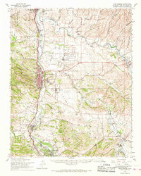
 1965 Atascadero1966 Print · USGSMid-century San Luis Obispo County comes to life as Atascadero expands between the Salinas River and the Santa Lucia mountains. Genealogists and historians can trace local landmarks like Santa Rosa Sch, the Atascadero State Hospital, and the heights of Cerro Alto Lookout.4 unique versions available
 - 1965 Map of Santa Margarita, 1967 Print
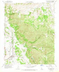 1965 Santa Margarita1967 Print · USGSSanta Margarita and the Salinas River valley are captured in the mid-sixties as the railroad and ranching culture shaped the landscape. Genealogists can locate family sites at the Santa Margarita Cemetery, the Asistencia de Santa Margarita (Ruins), and Garden Farms.3 unique versions available
End of results
Showing maps 1-3 of 3
Top cities near Atascadero
Top neighborhoods of Atascadero
- Asuncion historical maps
- Las Lomas Village historical maps
- Dove Creek historical maps
- Woodridge historical maps
Frequently asked questions
- What are the different types of historical maps available for Atascadero?
- What is the oldest map of Atascadero?
- Where can I purchase historical maps of Atascadero for my home or office?
- Where can I download high-res historical maps of Atascadero?
- Are there historical topographic maps available for Atascadero?
- Is there historical aerial imagery available for Atascadero?
- Where are historical maps of Atascadero sourced from?