1930s Maps of California Valley, California
Explore 3 historic maps of California Valley from the 1930s. These maps offer a rare glimpse into what life looked like during the 1930s — showing old roads, neighborhoods, homes, and landmarks that have changed or disappeared over time.
Whether you're researching your family's past, planning a metal detecting trip, or studying how California Valley's landscape evolved across the 1930s, these high-resolution maps are a powerful tool for exploring the history of this region.
- Focus on a specific era: All maps on this page are from the 1930s, giving you a focused view of this time period.
- See what’s changed: Compare century-old streets, trails, and buildings to today's modern landscape using overlays and satellite layers.
- Research with precision: Use these maps for genealogy, historical research, land use analysis, or educational projects.
- View, download, or print: Maps are fully viewable online in high resolution, and can be downloaded or printed for your own records.
Start exploring California Valley's history through authentic maps from the 1930s. This is your window into the past.
California Valley, CA maps
(3)- 1932 Map of La Panza
 1932 La Panza1932 Print · USGSSan Luis Obispo County ranch lands meet the high desert during the early 1930s. Genealogists and local historians can trace family-named outposts like La Panza Ranch, the waters of Carnaza Spr, and the remote French Camp.
 - 1935 Map of La Panza
 1935 La Panza1935 Print · USGSThe San Luis Obispo backcountry comes into focus during the mid-thirties, showing the rugged ranch lands between the mountains and the desert flats. Researchers can trace historic creek-side settlements like La Panza or locate water sources such as Mustang Spr and Carriaza Spr.
 - 1936 Map of La Panza
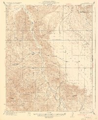 1936 La Panza1936 Print · USGSThe ranching and mining country of eastern San Luis Obispo County is captured here in the mid-1930s. Genealogists and researchers can trace family lands near La Panza Ranch, locate the camp at French Camp, or follow the course of Placer Creek.3 unique versions available
End of results
Showing maps 1-3 of 3
Frequently asked questions
- What are the different types of historical maps available for California Valley?
- What is the oldest map of California Valley?
- Where can I purchase historical maps of California Valley for my home or office?
- Where can I download high-res historical maps of California Valley?
- Are there historical topographic maps available for California Valley?
- Is there historical aerial imagery available for California Valley?
- Where are historical maps of California Valley sourced from?