
1932 Map of La Panza
USGS Topo · Published 1932About this map
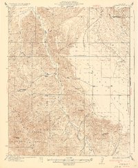
San Juan Creek flows through a landscape defined by deep canyons and the sprawling expanse of the Carrizo Plain during the early 1930s. The settlement at La Panza and the nearby La Panza Ranch serve as focal points for this cattle and ranching region of San Luis Obispo County. Local water sources are critical to the era’s economy, marked by locations such as Carnaza Spr and Mustang Spr. The map reveals a transition from the steep elevations of McChesney Mtn and Freeborn Mtn down into the flatlands of the plain. Evidence of early land management is visible in the 7th Standard Parallel South and the remote outpost at French Camp. To the east, the boundary between San Luis Obispo Co and Kern Co runs through the drainages of Bitterwater Creek.
Find a feature on this map
24 named features on this map. Tap any name to fly to it.
Don’t see what you’re looking for? This feature index may not catch every label — zoom into the map to look around manually.
Map Details
Editions of this 1932 La Panza Map
This is the sole edition of this map. No revisions or reprints were ever made.
Other maps of this area

1912 · McKittrick
USGS Topo · 1:125,000

1914 · Lost Hills
USGS Topo · 1:125,000

1914 · Cholame
USGS Topo · 1:125,000

1915 · Cholame
USGS Topo · 1:125,000

1917 · Cholame
USGS Topo · 1:125,000

1922 · Pozo
USGS Topo · 1:62,500

1922 · Nipomo
USGS Topo · 1:62,500

1935 · La Panza
USGS Topo · 1:62,500
1936 · La Panza
USGS Topo · 1:62,500

1937 · Branch Mtn
USGS Topo · 1:48,000