
1922 Map of Pozo
USGS Topo · Published 1922About this map
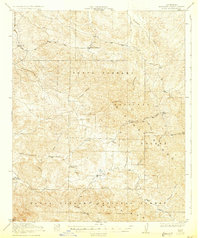
The upper headwaters of the Salinas River define this corner of San Luis Obispo County just after the first World War. The settlement at Pozo serves as a small anchor point within a landscape largely occupied by the Santa Barbara National Forest. At this time, the backcountry is dotted with rural educational outposts, including Huerhuero School, Highland School, and the remote New District School 1331, reflecting the scattered ranching and agricultural communities that relied on the seasonal flows of Pozo Creek and Huerhuero Creek. The topography is dominated by the steep rises of the La Panza Range, featuring prominent landmarks like Black Mtn and Las Chiches. Tracing the numerous canyons, such as Fraser Canyon and American Canyon, reveals the primitive road network that once connected these isolated mountain valleys.
Find a feature on this map
19 named features on this map. Tap any name to fly to it.
Don’t see what you’re looking for? This feature index may not catch every label — zoom into the map to look around manually.
Map Details
Editions of this 1922 Pozo Map
3 editions found

Other maps of this area

1897 · San Luis Obispo
USGS Topo · 1:62,500

1897 · Arroyo Grande
USGS Topo · 1:62,500

1900 · San Luis
USGS Topo · 1:125,000

1914 · Cholame
USGS Topo · 1:125,000

1915 · Cholame
USGS Topo · 1:125,000

1917 · Cholame
USGS Topo · 1:125,000

1919 · Paso Robles
USGS Topo · 1:62,500

1922 · Nipomo
USGS Topo · 1:62,500

1932 · La Panza
USGS Topo · 1:48,000

1935 · La Panza
USGS Topo · 1:62,500