1936 Map of La Panza
USGS Topo · Published 1936About this map
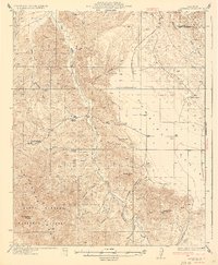
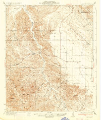
San Juan Creek cuts through the center of this landscape, anchoring a network of canyons and drainages in this pocket of San Luis Obispo County during the mid-1930s. The settlement at La Panza and the nearby La Panza Ranch represent the established ranching and agricultural life of the era, while the presence of Placer Creek points toward the region's historical mineral interests. To the south, the boundary of the Santa Barbara National Forest encompasses high points like Mc Chesney Mtn and Freeborn Mtn, marking a transition from the lower creek basins into the higher reaches of the Santa Lucia Range. The northeastern corner transitions toward the Kern County line, where the terrain begins to shift from the deep cuts of Old Canyon and Martinez Canyon into the more open areas around Yeguas Creek.
Find a feature on this map
28 named features on this map. Tap any name to fly to it.
Don’t see what you’re looking for? This feature index may not catch every label — zoom into the map to look around manually.
Map Details
Editions of this 1936 La Panza Map
3 editions found

Other maps of this area

1912 · McKittrick
USGS Topo · 1:125,000

1914 · Lost Hills
USGS Topo · 1:125,000

1914 · Cholame
USGS Topo · 1:125,000

1915 · Cholame
USGS Topo · 1:125,000

1917 · Cholame
USGS Topo · 1:125,000

1922 · Pozo
USGS Topo · 1:62,500

1922 · Nipomo
USGS Topo · 1:62,500

1932 · La Panza
USGS Topo · 1:48,000

1935 · La Panza
USGS Topo · 1:62,500

1937 · Branch Mtn
USGS Topo · 1:48,000