
1937 Map of Branch Mtn
USGS Topo · Published 1937About this map
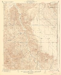
San Rafael Mountains topography dominates this landscape at the boundary of San Luis Obispo and Santa Barbara counties. The rugged interior is marked by a network of ranching homesteads such as Buckhorn Ranch, Scott Ranch, and Luelling Ranch, connected by primitive trails and the winding State Highway No 166. The confluence of Branch Creek and the Cuyama River provides a focal point for the terrain, while the Pine Canyon Guard Sta serves as a lone institutional marker in the backcountry. Land ownership and surveying complexities are evident in the margin notes, which highlight the difficulty of reconciling land plats along the Mt Diablo and San Bernardino Meridians. Small named features like Los Pelados and the Avenales Ranch hint at the seasonal grazing and early frontier life of this section of the coastal range.
Find a feature on this map
69 named features on this map. Tap any name to fly to it.
Don’t see what you’re looking for? This feature index may not catch every label — zoom into the map to look around manually.
Map Details
Editions of this 1937 Branch Mtn Map
This is the sole edition of this map. No revisions or reprints were ever made.
Other maps of this area

1902 · Santa Ynez
USGS Topo · 1:125,000

1905 · Santa Ynez
USGS Topo · 1:125,000

1905 · Lompoc
USGS Topo · 1:125,000

1912 · McKittrick
USGS Topo · 1:125,000

1922 · Pozo
USGS Topo · 1:62,500

1922 · Nipomo
USGS Topo · 1:62,500

1932 · La Panza
USGS Topo · 1:48,000

1935 · La Panza
USGS Topo · 1:62,500
1936 · La Panza
USGS Topo · 1:62,500

1941 · Caliente Mountain
USGS Topo · 1:62,500