Old Maps of Santa Barbara County, California
Explore 559 old maps of Santa Barbara County, spanning from 1902 to today. These high-resolution historic maps reveal how streets, neighborhoods, landmarks, and natural features evolved over time — perfect for genealogy, metal detecting, research, and local history exploration.
What you can do with these maps:
- See how Santa Barbara County changed over time: Compare historical maps to modern-day views to trace roads, homesites, rail lines & more.
- View detailed metadata: Each map includes creators, publishers, year, scale, and archive source.
- Overlay maps with satellite & LiDAR: Visualize the past alongside modern tools to explore terrain & human change.
- Trusted historical sources: Maps sourced from the USGS, Library of Congress, and other archives.
- Access maps your way: View online, download high-res files, or order prints for personal or research use.
Start exploring old maps of Santa Barbara County to uncover forgotten places, hidden landmarks, and the deep history beneath your feet.
Santa Barbara County, CA maps
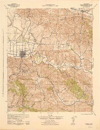
(559)- 1902 Map of Santa Ynez
 1902 Santa Ynez1902 Print · USGSSanta Barbara County at the turn of the century was a land of high mountain meadows and isolated ranching outposts. Genealogists can trace family holdings at Cuyama Ranch or follow old trails through Salisbury Potrero and the San Rafael Mountains.
 - 1903 Map of Mt. Pinos
 1903 Mt. Pinos1903 Print · USGSVentura and Kern counties at the start of the century remain largely a wild backcountry of forest reserves and high peaks. Genealogists and historians can trace early outposts like Pattiway, the high-altitude Frazier Borax Mine, and the Pine Mtn Lodge.7 unique versions available
 - 1904 Map of Ventura
 1904 Ventura1904 Print · USGSThe coastal shelf and interior valleys of Ventura County appear here in the early twentieth century, showing a landscape of ranchos and new rail lines. Genealogists and historians can locate early settlements like Matilija and Oakview or trace the Southern Pacific RR along the Santa Barbara Channel.6 unique versions available
 - 1905 Map of Guadalupe
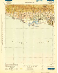
 1905 Guadalupe1905 Print · USGSThe Central California coast at the dawn of the century reveals a landscape shaped by the Southern Pacific R. R. and coastal trade. Genealogists and historians can trace rail-side settlements like Betteravia, Casmalia, and the old maritime Pt. Sal Landing.6 unique versions available
 - 1905 Map of Santa Ynez
 1905 Santa Ynez1905 Print · USGSThe Santa Barbara backcountry is shown here at the start of the twentieth century, focusing on the high ridges and canyons of the San Rafael Mountains. Genealogists and hikers can trace early routes through San Marcos Pass or locate old sites like Wasioja and the Montgomery Potrero.5 unique versions available
 - 1905 Map of Lompoc
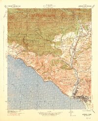
 1905 Lompoc1905 Print · USGSSanta Barbara County at the turn of the century reveals a landscape of historic ranchos and early industry before the rise of modern development. Researchers can trace the early Pacific Coast RR and locate heritage sites like Santa Ynez Mission and the Union Oil Wells.7 unique versions available
 - 1912 Map of McKittrick
 1912 McKittrick1912 Print · USGSKern and San Luis Obispo counties are shown here just as the early oil boom and cattle ranching were shaping the desert landscape. Researchers can trace the original Pacific Southern rail lines and find legacy ranch sites like Sandiego Joe's and Temblor Ranch.4 unique versions available
 - 1922 Map of Nipomo
 1922 Nipomo1922 Print · USGSThe ranching and rail landscape of coastal California is documented here shortly after the Great War. Genealogists can trace family holdings and local landmarks including the Pacific Coast Ry, the Colwell Ranch, and rural sites like the Santa Manuela School.4 unique versions available
 - 1937 Map of Branch Mtn
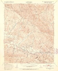
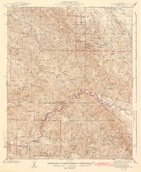
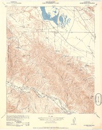
 1937 Branch Mtn1937 Print · USGSThe backcountry of San Luis Obispo and Santa Barbara counties is captured here in the late 1930s, showing a landscape defined by ranching and high peaks. Genealogists and historians can trace family holdings like the Carrizo Ranch, Gifford Ranch, and Rice Ranch along the banks of the Cuyama River.
 - 1941 Map of Ventura
 1941 Ventura1941 Print · USGSCoastal Ventura and the Ojai Valley are shown in the early 1940s, just as the region began its mid-century growth. Genealogists and historians can trace family properties like the Schafer Farm, locate the historic Matilija Hot Springs, or follow the Southern Pacific rail line.4 unique versions available
 - 1941 Map of San Rafael Mtn. , 1955 Print
 1941 San Rafael Mtn.1955 Print · USGSSanta Barbara County’s backcountry comes into focus during the early 1940s, showing a rugged landscape of high peaks and river-valley ranches. Researchers can locate remote sites like the Redrock Quicksilver Mine and Rancho San Fernando Rey or trace the route to Cold Spring Tavern.3 unique versions available
 - 1941 Map of Caliente Mountain, 1956 Print
 1941 Caliente Mountain1956 Print · USGSThe Carrizo Plain and its surrounding mountain ranges are captured here in the early 1940s, documenting a landscape of remote cattle ranches and high desert basins. Researchers can trace the legacy of family holdings like Spanish Ranch and Washburn Ranch or locate natural features such as Soda Lake and Painted Rock.
 - 1941 Map of McPherson Peak, 1956 Print
 1941 McPherson Peak1956 Print · USGSThe northern Santa Barbara backcountry is seen here in the early 1940s, highlighting the transition from the Cuyama River valley into the high Sierra Madres. Researchers can locate remote ranch sites and forest landmarks such as Hinsdale Ranch, the Wasioja Sch, and the Hurricane Deck ridge.3 unique versions available
 - 1942 Map of Point Arguello
 1942 Point Arguello1942 Print · USGSThe Santa Barbara coast during the early years of the war reveals a landscape of rugged canyons and vital rail connections. Researchers can trace the early ranching and school districts at Artesia Sch and Lynden Sch, or explore coastal operations at Lompoc Landing.2 unique versions available
 - 1942 Map of Guadalupe
 1942 Guadalupe1942 Print · USGSThe Central Coast during the early war years reveals a landscape of coastal rail stations and ranching canyons along the Santa Barbara shore. Researchers can trace the Southern Pacific line through Surf and Honda to find vanished spurs and schools like Lynden Sch.
 - 1942 Map of Lompoc
 1942 Lompoc1942 Print · USGSSanta Barbara County at the start of World War II reveals a landscape of missions, ranching, and coastal rail. Researchers can trace the Pacific Coast Railroad, locate historic schools like Sisquoc Sch, and find the remote Asphaltum Mine.
 - 1942 Map of Lompoc
 1942 Lompoc1942 Print · USGSSanta Barbara County’s coastal valleys were a mix of industrial mining and historic ranching during the early 1940s. Genealogists and researchers can locate several rural schoolhouses like Maple Sch and San Julian Sch, or trace the Southern Pacific rail line.2 unique versions available
 - 1942 Map of Pt. Conception
 1942 Pt. Conception1942 Print · USGSCoastal Santa Barbara County appears in the early years of the war, centered on the strategic maritime and rail junction at the headlands. Researchers can trace the shoreline path of the Southern Pacific railroad past San Augustin and the notable Pt. Conception lighthouse site.3 unique versions available
 - 1942 Map of Santa Maria
 1942 Santa Maria1942 Print · USGSSanta Barbara County was a hub of petroleum production and river-valley agriculture in the early 1940s. Genealogists and local historians can trace the early footprints of Santa Maria, the Santa Maria Valley Oil Field, and rural stops like Bicknell and Orcutt.
 - 1942 Map of Branch Mountain
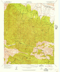
 1942 Branch Mountain1942 Print · USGSSan Luis Obispo and Santa Barbara counties meet along the high ridges and river canyons of the interior in the early 1940s. Genealogists and historians can trace pioneer outposts like Scott Ranch and Avenales Ranch or locate the remote Pine Canyon Guard Sta.3 unique versions available
 - 1942 Map of Gaviota
 1942 Gaviota1942 Print · USGSThe Santa Barbara coast during the early years of the war reveals a narrow corridor of railroad and ranching life between the sea and the mountains. Genealogists and researchers can trace the coastal route through Alcatraz, Tajiguas, and the strategic passage at Gaviota Pass.
 - 1942 Map of Point Sal
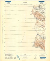
 1942 Point Sal1942 Print · USGSThe Santa Barbara coast during the early war years is shown here in high detail, from the river valley down to the Pacific cliffs. Genealogists and researchers can trace the rail settlements at Narlon, the rural community at Casmalia, and the local Bonita Sch.
 - 1942 Map of Goleta, 1943 Print
 1942 Goleta1943 Print · USGSThe Santa Barbara coastline in the early 1940s reveals a world of historic ranchos and coastal canyons before the post-war boom. Trace the footprints of the Corona Del Mar Rancho, Dos Pueblos Ranch, and the rail stops at Naples.
 - 1942 Map of San Rafael Mtn. , 1945 Print
 1942 San Rafael Mtn.1945 Print · USGSThe Santa Barbara backcountry in the early 1940s is shown here as a network of canyon ranches and mountain fire lookouts. Genealogists and historians can trace family properties like Storke Ranch or locate the Redrock Quicksilver Mine and Cold Spring Tavern.
 - 1942 Map of Caliente Mtn, 1952 Print
 1942 Caliente Mtn1952 Print · USGSCoastal California’s interior highlands were a domain of remote ranching and seasonal water sources during the early 1940s. Genealogists and historians can trace old homesteads like Goodwin Ranch and Spanish Ranch or locate the historic Painted Rock landmark.2 unique versions available
Showing maps 1-25 of 559
Top cities of Santa Barbara County
- Santa Maria historical maps
- Santa Barbara historical maps
- Lompoc historical maps
- Lompoc historical maps
- Orcutt historical maps
- Goleta historical maps
See more
Frequently asked questions
- What are the different types of historical maps available for Santa Barbara County?
- What is the oldest map of Santa Barbara County?
- Where can I purchase historical maps of Santa Barbara County for my home or office?
- Where can I download high-res historical maps of Santa Barbara County?
- Are there historical topographic maps available for Santa Barbara County?
- Is there historical aerial imagery available for Santa Barbara County?
- Where are historical maps of Santa Barbara County sourced from?