
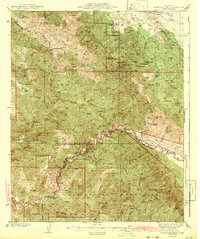
1942 Map of Branch Mountain
USGS Topo · Published 1942About this map
The Cuyama River carves a deep path through the interior of the Central Coast, marking the jagged boundary between San Luis Obispo and Santa Barbara counties. This 1942 edition, based on surveys from 1919 and 1937, details a high-elevation landscape defined by the La Panza Range and the San Rafael Mountains. Remote ranching outposts such as Avenales Ranch, Buckhorn Ranch, and Joughin Ranch are situated along the canyons, highlighting the area's history of isolated cattle operations and land usage before modern accessibility. Notable landmarks like the Pine Canyon Guard Sta and the intersection of the Mt Diablo and San Bernardino base and meridian lines provide essential reference points for land surveyors and historians tracing the development of public land records in California.
Find a feature on this map
58 named features on this map. Tap any name to fly to it.
Don’t see what you’re looking for? This feature index may not catch every label — zoom into the map to look around manually.
Map Details
Editions of this 1942 Branch Mountain Map
3 editions found
Other maps of this area

1902 · Santa Ynez
USGS Topo · 1:125,000

1905 · Santa Ynez
USGS Topo · 1:125,000

1905 · Lompoc
USGS Topo · 1:125,000

1912 · McKittrick
USGS Topo · 1:125,000

1922 · Pozo
USGS Topo · 1:62,500

1922 · Nipomo
USGS Topo · 1:62,500

1932 · La Panza
USGS Topo · 1:48,000

1935 · La Panza
USGS Topo · 1:62,500

1936 · La Panza
USGS Topo · 1:62,500

1937 · Branch Mtn
USGS Topo · 1:48,000