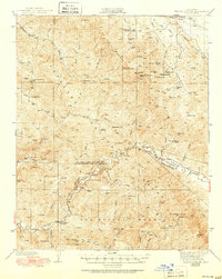
1942 Map of Branch Mtn
USGS Topo · Published 1951About this map
The La Panza Range and the San Rafael Mountains dominate this 1942 survey of the high country along the San Luis Obispo and Santa Barbara County line. This landscape is defined by remote ranching outposts and high-elevation water sources, where family-named holdings like Joughin Ranch, Scott Ranch, and Pernasse Ranch were established near vital springs. The rugged drainage systems of the Cuyama River and Salinas River provide the primary geographical orientation for the region, carving deep canyons such as Gypsum Canyon and Brown Canyon.
Find a feature on this map
65 named features on this map. Tap any name to fly to it.
Don’t see what you’re looking for? This feature index may not catch every label — zoom into the map to look around manually.
Map Details
Editions of this 1942 Branch Mtn Map
3 editions found

Other maps of this area

1902 · Santa Ynez
USGS Topo · 1:125,000

1905 · Santa Ynez
USGS Topo · 1:125,000

1905 · Lompoc
USGS Topo · 1:125,000

1912 · McKittrick
USGS Topo · 1:125,000

1922 · Pozo
USGS Topo · 1:62,500

1922 · Nipomo
USGS Topo · 1:62,500

1932 · La Panza
USGS Topo · 1:48,000

1935 · La Panza
USGS Topo · 1:62,500

1936 · La Panza
USGS Topo · 1:62,500

1937 · Branch Mtn
USGS Topo · 1:48,000