1950s Maps of Santa Barbara County, California
Explore 60 historic maps of Santa Barbara County from the 1950s. These maps offer a rare glimpse into what life looked like during the 1950s — showing old roads, neighborhoods, homes, and landmarks that have changed or disappeared over time.
Whether you're researching your family's past, planning a metal detecting trip, or studying how Santa Barbara County's landscape evolved across the 1950s, these high-resolution maps are a powerful tool for exploring the history of this region.
- Focus on a specific era: All maps on this page are from the 1950s, giving you a focused view of this time period.
- See what’s changed: Compare century-old streets, trails, and buildings to today's modern landscape using overlays and satellite layers.
- Research with precision: Use these maps for genealogy, historical research, land use analysis, or educational projects.
- View, download, or print: Maps are fully viewable online in high resolution, and can be downloaded or printed for your own records.
Start exploring Santa Barbara County's history through authentic maps from the 1950s. This is your window into the past.
Santa Barbara County, CA maps
(60)- 1950 Map of San Miguel Island West
 1950 San Miguel Island West1950 Print · USGSThe western reaches of San Miguel Island are captured here during the mid-forty-year period, showing the isolated New San Miguel Latitude Station. Trace the wind-swept coast from Point Bennett to the heights of Green Mountain.
 - 1950 Map of San Miguel Island East
 1950 San Miguel Island East1950 Print · USGSSan Miguel Island at the midpoint of the twentieth century shows a landscape of solitary outposts and coastal hazards. Researchers can locate the Ranch and Ranch House Flagpole or trace the shoreline from Harris Point to Cardwell Point.
 - 1950 Map of Pitas Point, 1955 Print
 1950 Pitas Point1955 Print · USGSCoastal Ventura County comes into focus in the early fifties, showing the narrow passage between the steep hills and the Pacific Ocean. Researchers can trace the railroad line past Punta and locate water sources like Los Sauces Creek and Rincon Cr.3 unique versions available
 - 1950 Map of Goleta, 1957 Print
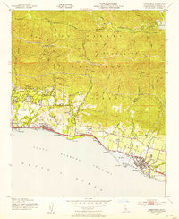
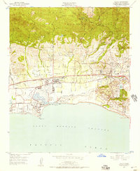 1950 Goleta1957 Print · USGSCoastal Santa Barbara County transitions from agricultural ranching to a regional aviation and education hub in the early fifties. Genealogists and historians can trace the foundations of the University of California campus alongside legacy landmarks like the Goleta Cem and Devereux Ranch.6 unique versions available
 - 1951 Map of Dos Pueblos Canyon
 1951 Dos Pueblos Canyon1951 Print · USGSThe Santa Barbara coast transitioned from ranching to mid-century development as the early 1950s gave way to the 1980s. Trace the legacy of Los Dos Pueblos along the Southern Pacific rail line and locate landmarks like Naples and the Ellwood Union Sch.9 unique versions available
 - 1951 Map of Goleta
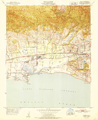 1951 Goleta1951 Print · USGSCoastal Santa Barbara County appears here in the early fifties, caught between its deep-rooted ranching history and the rise of modern institutions. Local researchers can trace the early footprint of the University of California and old landmarks like Goleta Cem and Mescalitan Island.
 - 1951 Map of Pitas Point
 1951 Pitas Point1951 Print · USGSThe Ventura coast in the early fifties shows a busy corridor of petroleum production and transit squeezed between the mountains and the sea. You can trace the Southern Pacific tracks and Highway 101 past the settlement of Sea Cliff and numerous Oil Wells.2 unique versions available
 - 1952 Map of Caliente Mountain
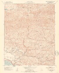
 1952 Caliente Mountain1952 Print · USGSThe high desert of the Carrizo Plain and the steep Caliente Range are captured here in the early fifties. Researchers can locate remote family operations like Goodwin Ranch, find the Painted Rock landmark, and trace the Cuyama River canyon.
 - 1952 Map of Carpinteria, 1953 Print
 1952 Carpinteria1953 Print · USGSThe Santa Barbara coast during the early fifties shows a burgeoning network of seaside towns and mountain routes. Genealogists can trace family landmarks like Carpinteria Cemetery, Aliso Sch, and the residential growth near Sandyland Cove.8 unique versions available
 - 1952 Map of Branch Mountain, 1953 Print
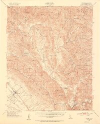
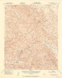 1952 Branch Mountain1953 Print · USGSThe rugged interior of the Central Coast is seen here during the early fifties, characterized by remote cattle operations and mountain trails. Genealogists and local historians can trace legacy holdings like Carrisa Ranch, Gifford Ranch, and the Gline Ranch Corral.3 unique versions available
 - 1952 Map of White Ledge Peak, 1953 Print
 1952 White Ledge Peak1953 Print · USGSThe Santa Barbara coast and its inland mountains are captured here in the early fifties, showing the interplay of ranching and early aviation. Genealogists can trace family landmarks like Botello Ranch, locate the Cate School, or study the remote Billiard Flats.6 unique versions available
 - 1952 Map of Nipomo, 1953 Print
 1952 Nipomo1953 Print · USGSCoastal ridges and interior ranchlands define this mid-century look at the southern San Luis Obispo back country. Local historians can trace old family holdings like Tar Springs Ranch and Porter Ranch or locate the Santa Manuela School.3 unique versions available
 - 1952 Map of Santa Barbara, 1953 Print
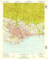 1952 Santa Barbara1953 Print · USGSSanta Barbara and Montecito are captured in the early fifties as the coastal plain developed below the Santa Ynez Mountains. Genealogists and local historians can trace the campuses of Westmont College, the historic Santa Barbara Mission, and the grounds of the Santa Barbara Cemetery.6 unique versions available
 - 1953 Map of Sacate, 1954 Print
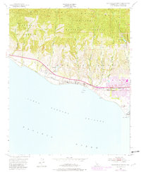
 1953 Sacate1954 Print · USGSThis coastal section of Santa Barbara County in the early fifties shows a rugged shoreline dominated by the railroad and historic ranching grants. Genealogists and researchers can trace the rail sidings and small settlements at Sacate, Drake, and the historic Santa Anita Ranch.6 unique versions available
 - 1953 Map of Gaviota, 1954 Print
 1953 Gaviota1954 Print · USGSThe Santa Barbara coastline and the Santa Ynez range meet at the Gaviota Pass in the early fifties. Researchers can trace the coastal route of the Southern Pacific railroad and locate local landmarks like the Vista Del Mar Union Sch and Las Cruces.6 unique versions available
 - 1953 Map of Tajiguas, 1954 Print
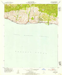 1953 Tajiguas1954 Print · USGSThe Santa Barbara coast during the early fifties reveals a landscape of industrial oil production and historic ranching legacies. Researchers can trace the Southern Pacific tracks past Tajiguas Ranch and locate early coastal energy infrastructure like the Oil Tanks at Capitan.5 unique versions available
 - 1953 Map of Point Conception, 1954 Print
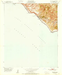
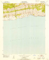
 1953 Point Conception1954 Print · USGSThe Santa Barbara coast during the early fifties reveals a landscape of isolated ranching and maritime surveillance at the turn of the Pacific. Researchers can trace the Southern Pacific rail line past the Lighthouse and through the remote outposts of Concepcion and Cojo Ranch.4 unique versions available
 - 1955 Map of Los Angeles
 1955 Los Angeles1955 Print · USGSThe mid-century transformation of Southern California comes into focus as the urban sprawl of Los Angeles meets the wilderness of the Santa Monica Mountains. Researchers can trace the development of post-war suburbs alongside historic landmarks like the Santa Barbara Lighthouse and early industrial sites such as the Good Luck Mine.
 - 1955 Map of Bakersfield
 1955 Bakersfield1955 Print · USGSThe southern San Joaquin Valley in the mid-fifties shows an era of massive oil production and industrial irrigation. Trace family roots in Allensworth, the oil fields of Oildale, or the shorelines of Tulare Lake and Buena Vista Lake.
 - 1956 Map of Bakersfield
 1956 Bakersfield1956 Print · USGSThe southern San Joaquin Valley and High Sierra come alive in the mid-fifties, showing the region's complex agricultural and rail networks. Genealogists and historians can trace family roots in towns like Bakersfield, Taft, and Delano, or locate early infrastructure along the Sunset Railway.
 - 1956 Map of San Luis Obispo, 1963 Print
 1956 San Luis Obispo1963 Print · USGSCentral California coastal and valley life unfolds in the mid-fifties, from the shoreline of Pismo Beach to the arid Carrizo Plain. Trace early travel routes along the Southern Pacific RR or locate family sites near the Templeton Cemetery and Paso Robles County Cemetery.5 unique versions available
 - 1956 Map of Santa Maria, 1973 Print
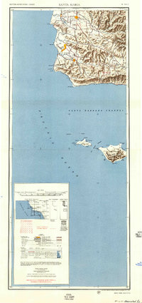
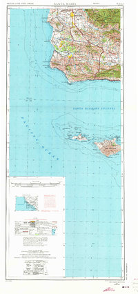 1956 Santa Maria1973 Print · USGSThe Central Coast landscape at the height of the Cold War reveals a mix of aerospace expansion and historic ranching towns. Trace the early footprint of Vandenberg AFB or locate coastal rail stops like Surf and the mission site at La Purisima Mission State Park.2 unique versions available
 - 1957 Map of Long Beach
 1957 Long Beach1957 Print · USGSThe Los Angeles coast and the Channel Islands appear here during the mid-fifties era of rapid suburbanization and naval expansion. Genealogists and researchers can locate early industrial neighborhoods like South Gate and trace military boundaries at Ft MacArthur Upper Reservation or the remote San Nicolas Island.4 unique versions available
 - 1957 Map of San Luis Obispo
 1957 San Luis Obispo1957 Print · USGSCoastal California in the late fifties is defined by the steep Santa Lucia Range and the rail-connected hub of San Luis Obispo. Genealogists and researchers can trace rural life via Union School, the Southern Pacific line, and old sites like the Polar Star Mine.
 - 1957 Map of Santa Maria
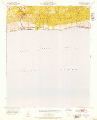
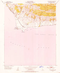
 1957 Santa Maria1957 Print · USGSCoastal Santa Barbara County is captured here during the mid-fifties, showing a landscape defined by military installations and petroleum production. Researchers can trace the Southern Pacific rail line and locate rural landmarks like Honda School, Betteravia, and the John Manville Plant.
Showing maps 1-25 of 60
Top cities of Santa Barbara County
- Santa Maria historical maps
- Santa Barbara historical maps
- Lompoc historical maps
- Lompoc historical maps
- Orcutt historical maps
- Goleta historical maps
See more
Frequently asked questions
- What are the different types of historical maps available for Santa Barbara County?
- What is the oldest map of Santa Barbara County?
- Where can I purchase historical maps of Santa Barbara County for my home or office?
- Where can I download high-res historical maps of Santa Barbara County?
- Are there historical topographic maps available for Santa Barbara County?
- Is there historical aerial imagery available for Santa Barbara County?
- Where are historical maps of Santa Barbara County sourced from?