1960s Maps of Cayucos, California
Explore 2 historic maps of Cayucos from the 1960s. These maps offer a rare glimpse into what life looked like during the 1960s — showing old roads, neighborhoods, homes, and landmarks that have changed or disappeared over time.
Whether you're researching your family's past, planning a metal detecting trip, or studying how Cayucos's landscape evolved across the 1960s, these high-resolution maps are a powerful tool for exploring the history of this region.
- Focus on a specific era: All maps on this page are from the 1960s, giving you a focused view of this time period.
- See what’s changed: Compare century-old streets, trails, and buildings to today's modern landscape using overlays and satellite layers.
- Research with precision: Use these maps for genealogy, historical research, land use analysis, or educational projects.
- View, download, or print: Maps are fully viewable online in high resolution, and can be downloaded or printed for your own records.
Start exploring Cayucos's history through authentic maps from the 1960s. This is your window into the past.
Cayucos, CA maps
(2)- 1965 Map of Cayucos, 1967 Print
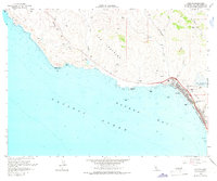 1965 Cayucos1967 Print · USGSCoastal San Luis Obispo County comes alive in the mid-sixties as the town of Cayucos expands near the newly established Whale Rock Reservoir. Trace family history at the Cayucos-Morro Bay District Cem or explore the rugged shoreline from Point Estero to China Harbor.3 unique versions available
 - 1965 Map of Morro Bay North, 1968 Print
 1965 Morro Bay North1968 Print · USGSCoastal San Luis Obispo County is shown here during the mid-sixties, capturing the intersection of ranching heritage and modern utility. Trace the development of Whale Rock Reservoir and locate local landmarks like Fairview Sch and Del Mar Sch.2 unique versions available
End of results
Showing maps 1-2 of 2
Top cities near Cayucos
- San Luis Obispo historical maps
- Atascadero historical maps
- Paso Robles historical maps
- Morro Bay historical maps
- Cambria historical maps
Frequently asked questions
- What are the different types of historical maps available for Cayucos?
- What is the oldest map of Cayucos?
- Where can I purchase historical maps of Cayucos for my home or office?
- Where can I download high-res historical maps of Cayucos?
- Are there historical topographic maps available for Cayucos?
- Is there historical aerial imagery available for Cayucos?
- Where are historical maps of Cayucos sourced from?