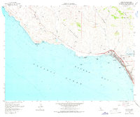
1965 Map of Cayucos
USGS Topo · Published 1967About this map
Cayucos sits along the curve of Estero Bay in this mid-1960s topographic record, where the coastal landscape transitions from the rugged points of the Santa Lucia foothills to the sandy stretches of Cayucos State Beach. The community is anchored by the Whale Rock Reservoir, a critical piece of local water infrastructure completed just years before this survey. The coastline is defined by hazardous maritime features such as Point Estero, China Harbor, and Whale Rock, which have historically shaped the navigation of this stretch of the Pacific Ocean.
Find a feature on this map
26 named features on this map. Tap any name to fly to it.
Don’t see what you’re looking for? This feature index may not catch every label — zoom into the map to look around manually.
Map Details
Editions of this 1965 Cayucos Map
3 editions found
Other maps of this area

1897 · Cayucos
USGS Topo · 1:62,500

1900 · San Luis
USGS Topo · 1:125,000

1919 · Adelaida
USGS Topo · 1:62,500

1919 · San Simeon
USGS Topo · 1:62,500

1932 · Adelaida
USGS Topo · 1:62,500

1937 · Cayucos
USGS Topo · 1:62,500

1937 · San Simeon
USGS Topo · 1:62,500

1942 · Adelaida
USGS Topo · 1:62,500

1943 · Cayucos
USGS Topo · 1:62,500

1947 · San Luis Obispo
USGS Topo · 1:250,000