
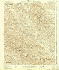
1932 Map of Adelaida
USGS Topo · Published 1932About this map
The Santa Lucia Range dominates this landscape, where early twentieth-century ranchers and farmers established a network of small school districts and mountain crossings. Centered on the settlement of Adelaida, the map reveals a community defined by its remote topography, with the Nacimiento River winding through the northern canyons near the Williams Ranch. The presence of several distinct schoolhouses, including Lincoln School, Summit School, and Josephine School, illustrates the decentralized nature of rural education in San Luis Obispo County before school consolidation. High peaks such as Cypress Mountain and Lime Mountain served as landmarks for travelers on the Paso Robles Road, while the German Church stands as a cultural marker in the foothills. To the south, the terrain descends toward San Geronimo, tracing the complex drainage basins of Las Tablas Creek and Jack Creek.
Find a feature on this map
39 named features on this map. Tap any name to fly to it.
Don’t see what you’re looking for? This feature index may not catch every label — zoom into the map to look around manually.
Map Details
Editions of this 1932 Adelaida Map
2 editions found
Other maps of this area

1897 · San Luis Obispo
USGS Topo · 1:62,500

1897 · Cayucos
USGS Topo · 1:62,500

1900 · San Luis
USGS Topo · 1:125,000

1919 · San Miguel
USGS Topo · 1:62,500

1919 · Bryson
USGS Topo · 1:62,500

1919 · Paso Robles
USGS Topo · 1:62,500

1919 · Bradley
USGS Topo · 1:62,500

1919 · Adelaida
USGS Topo · 1:62,500

1919 · San Simeon
USGS Topo · 1:62,500

1937 · Cayucos
USGS Topo · 1:62,500