1960s Maps of Cholame, California
Explore 2 historic maps of Cholame from the 1960s. These maps offer a rare glimpse into what life looked like during the 1960s — showing old roads, neighborhoods, homes, and landmarks that have changed or disappeared over time.
Whether you're researching your family's past, planning a metal detecting trip, or studying how Cholame's landscape evolved across the 1960s, these high-resolution maps are a powerful tool for exploring the history of this region.
- Focus on a specific era: All maps on this page are from the 1960s, giving you a focused view of this time period.
- See what’s changed: Compare century-old streets, trails, and buildings to today's modern landscape using overlays and satellite layers.
- Research with precision: Use these maps for genealogy, historical research, land use analysis, or educational projects.
- View, download, or print: Maps are fully viewable online in high resolution, and can be downloaded or printed for your own records.
Start exploring Cholame's history through authentic maps from the 1960s. This is your window into the past.
Cholame, CA maps
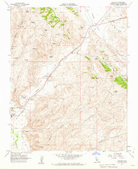
(2)- 1961 Map of Shandon, 1962 Print
 1961 Shandon1962 Print · USGSEastern San Luis Obispo County is captured here in the early sixties as an expansive ranching and agricultural district. Genealogists and researchers can locate old family sites like Clarke Ranch, the Shandon Cemetery, and the Eddys Camp site.2 unique versions available
 - 1961 Map of Cholame, 1962 Print
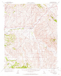
 1961 Cholame1962 Print · USGSCentral California ranching country and the San Andreas Fault corridor appear here in the early sixties. Researchers can trace the layout of Cholame and Shandon, locate the Shandon Cemetery, and follow the path of Cholame Creek through the hills.4 unique versions available
End of results
Showing maps 1-2 of 2
Top cities near Cholame
Frequently asked questions
- What are the different types of historical maps available for Cholame?
- What is the oldest map of Cholame?
- Where can I purchase historical maps of Cholame for my home or office?
- Where can I download high-res historical maps of Cholame?
- Are there historical topographic maps available for Cholame?
- Is there historical aerial imagery available for Cholame?
- Where are historical maps of Cholame sourced from?