1960s Maps of Grover Beach, California
Explore 3 historic maps of Grover Beach from the 1960s. These maps offer a rare glimpse into what life looked like during the 1960s — showing old roads, neighborhoods, homes, and landmarks that have changed or disappeared over time.
Whether you're researching your family's past, planning a metal detecting trip, or studying how Grover Beach's landscape evolved across the 1960s, these high-resolution maps are a powerful tool for exploring the history of this region.
- Focus on a specific era: All maps on this page are from the 1960s, giving you a focused view of this time period.
- See what’s changed: Compare century-old streets, trails, and buildings to today's modern landscape using overlays and satellite layers.
- Research with precision: Use these maps for genealogy, historical research, land use analysis, or educational projects.
- View, download, or print: Maps are fully viewable online in high resolution, and can be downloaded or printed for your own records.
Start exploring Grover Beach's history through authentic maps from the 1960s. This is your window into the past.
Grover Beach, CA maps
(3)- 1965 Map of Oceano, 1966 Print
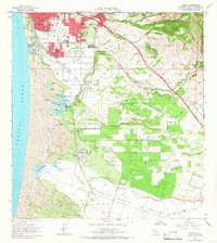 1965 Oceano1966 Print · USGSThe coastal dunes and agricultural mesas of San Luis Obispo County are captured here in the mid-sixties during a period of industrial and residential growth. Genealogists and historians can trace the rail-side infrastructure of Callender, including an oil refinery, or locate family sites in Grover City and Halcyon.2 unique versions available
 - 1965 Map of Arroyo Grande NE, 1967 Print
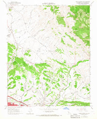 1965 Arroyo Grande NE1967 Print · USGSThe Central Coast hinterlands near Edna were a hub of rail activity and oil production in the mid-sixties. Genealogists and local historians can trace the foundations of the community through several local schools, the Southern Pacific corridor, and the Arroyo Grande Oil Field.6 unique versions available
 - 1965 Map of Pismo Beach, 1967 Print
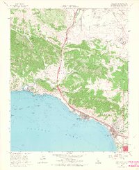 1965 Pismo Beach1967 Print · USGSThe Central Coast is documented during the mid-1960s as the seaside towns of the San Luis Obispo Bay began to expand. Genealogists and local historians can trace family-named sites like Squire Canyon and Gragg Canyon or locate early landmarks like Ontario Hot Springs and the Southern Pacific line.4 unique versions available
End of results
Showing maps 1-3 of 3
Top cities near Grover Beach
- Santa Maria historical maps
- San Luis Obispo historical maps
- Arroyo Grande historical maps
- Pismo Beach historical maps
- Oceano historical maps
- Guadalupe historical maps
See more
Frequently asked questions
- What are the different types of historical maps available for Grover Beach?
- What is the oldest map of Grover Beach?
- Where can I purchase historical maps of Grover Beach for my home or office?
- Where can I download high-res historical maps of Grover Beach?
- Are there historical topographic maps available for Grover Beach?
- Is there historical aerial imagery available for Grover Beach?
- Where are historical maps of Grover Beach sourced from?