1990s Maps of Morro Bay, California
Explore 2 historic maps of Morro Bay from the 1990s. These maps offer a rare glimpse into what life looked like during the 1990s — showing old roads, neighborhoods, homes, and landmarks that have changed or disappeared over time.
Whether you're researching your family's past, planning a metal detecting trip, or studying how Morro Bay's landscape evolved across the 1990s, these high-resolution maps are a powerful tool for exploring the history of this region.
- Focus on a specific era: All maps on this page are from the 1990s, giving you a focused view of this time period.
- See what’s changed: Compare century-old streets, trails, and buildings to today's modern landscape using overlays and satellite layers.
- Research with precision: Use these maps for genealogy, historical research, land use analysis, or educational projects.
- View, download, or print: Maps are fully viewable online in high resolution, and can be downloaded or printed for your own records.
Start exploring Morro Bay's history through authentic maps from the 1990s. This is your window into the past.
Morro Bay, CA maps
(2)- 1995 Map of Morro Bay North, 2000 Print
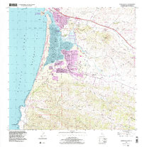
 1995 Morro Bay North2000 Print · USGSCentral Coast life in the mid-nineties shows the town of Morro Bay nestled between the coastal range and Estero Bay. Researchers can trace the development of local schools and parks like Lila Keiser Park alongside the rugged terrain of Rusty Peak.
 - 1998 Map of Morro Bay South, 2003 Print
 1998 Morro Bay South2003 Print · USGSThe California coast near Morro Bay is captured here in the late twentieth century, showing a landscape defined by volcanic peaks and tidal estuaries. Researchers can trace local history through sites like Quintana Cemetery, Sunnyside Sch, and the residential growth of Baywood Park.
End of results
Showing maps 1-2 of 2
Top cities near Morro Bay
- San Luis Obispo historical maps
- Atascadero historical maps
- Paso Robles historical maps
- Pismo Beach historical maps
- Cambria historical maps
- Avila Beach historical maps
Frequently asked questions
- What are the different types of historical maps available for Morro Bay?
- What is the oldest map of Morro Bay?
- Where can I purchase historical maps of Morro Bay for my home or office?
- Where can I download high-res historical maps of Morro Bay?
- Are there historical topographic maps available for Morro Bay?
- Is there historical aerial imagery available for Morro Bay?
- Where are historical maps of Morro Bay sourced from?