1940s Maps of Butano Park, California
Explore 6 historic maps of Butano Park from the 1940s. These maps offer a rare glimpse into what life looked like during the 1940s — showing old roads, neighborhoods, homes, and landmarks that have changed or disappeared over time.
Whether you're researching your family's past, planning a metal detecting trip, or studying how Butano Park's landscape evolved across the 1940s, these high-resolution maps are a powerful tool for exploring the history of this region.
- Focus on a specific era: All maps on this page are from the 1940s, giving you a focused view of this time period.
- See what’s changed: Compare century-old streets, trails, and buildings to today's modern landscape using overlays and satellite layers.
- Research with precision: Use these maps for genealogy, historical research, land use analysis, or educational projects.
- View, download, or print: Maps are fully viewable online in high resolution, and can be downloaded or printed for your own records.
Start exploring Butano Park's history through authentic maps from the 1940s. This is your window into the past.
Butano Park, CA maps
(6)- 1940 Map of Ano Nuevo, 1943 Print
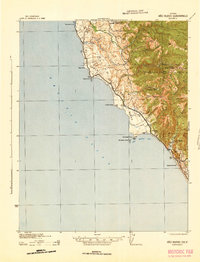
 1940 Ano Nuevo1943 Print · USGSThe San Mateo and Santa Cruz coastlines appear here in the early 1940s, highlighting a period of rural ranching and isolated coastal outposts. Genealogists and historians can trace the locations of Coastways Ranch, the Whitehouse Camp, and Trantor.
 - 1941 Map of Ano Nuevo Pt.
 1941 Ano Nuevo Pt.1941 Print · USGSThe rugged San Mateo coastline comes alive in the early 1940s, showing a landscape of maritime navigation and coastal ranching. Genealogy and history buffs can locate early landmarks like Pigeon Point LH, Notley Junction, and the historic Coastways Ranch.
 - 1942 Map of Ano Nuevo
 1942 Ano Nuevo1942 Print · USGSThe Central Coast south of Pescadero appears in this wartime survey, showing a landscape of remote ranching and prominent maritime landmarks. Researchers can trace early 20th-century coastal sites like Coastways Ranch, Notley Junction, and the iconic Pigeon Point light station.2 unique versions available
 - 1947 Map of San Francisco, 1948 Print
 1947 San Francisco1948 Print · USGSThe Bay Area in the late 1940s reveals a region transitioning from wartime intensity to post-war suburban growth. Trace the historic rail lines of the Southern Pacific RR or locate early military footprints at Fort Funston and Moffett Field.
 - 1948 Map of San Francisco, 1951 Print
 1948 San Francisco1951 Print · USGSThe Bay Area in the late 1940s reveals a landscape defined by rapid post-war growth and a heavy military presence at the Golden Gate. Trace the development of early trans-bay infrastructure like the Oakland-Bay Bridge and historic coastal defense sites such as Fort Funston and Alcatraz Island.
 - 1948 Map of Ano Nuevo, 1961 Print
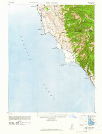 1948 Ano Nuevo1961 Print · USGSThe San Mateo and Santa Cruz coast is documented here in the decade following the Great Depression. Trace early coastal land use through landmarks like Whitehouse Camp (Abandoned), the Chalks Lookout, and Coastways Ranch.2 unique versions available
End of results
Showing maps 1-6 of 6
Top cities near Butano Park
- Redwood City historical maps
- Mountain View historical maps
- Palo Alto historical maps
- Santa Cruz historical maps
- Menlo Park historical maps
- East Palo Alto historical maps
See more
Frequently asked questions
- What are the different types of historical maps available for Butano Park?
- What is the oldest map of Butano Park?
- Where can I purchase historical maps of Butano Park for my home or office?
- Where can I download high-res historical maps of Butano Park?
- Are there historical topographic maps available for Butano Park?
- Is there historical aerial imagery available for Butano Park?
- Where are historical maps of Butano Park sourced from?