1990s Maps of Martins Beach, California
Explore 2 historic maps of Martins Beach from the 1990s. These maps offer a rare glimpse into what life looked like during the 1990s — showing old roads, neighborhoods, homes, and landmarks that have changed or disappeared over time.
Whether you're researching your family's past, planning a metal detecting trip, or studying how Martins Beach's landscape evolved across the 1990s, these high-resolution maps are a powerful tool for exploring the history of this region.
- Focus on a specific era: All maps on this page are from the 1990s, giving you a focused view of this time period.
- See what’s changed: Compare century-old streets, trails, and buildings to today's modern landscape using overlays and satellite layers.
- Research with precision: Use these maps for genealogy, historical research, land use analysis, or educational projects.
- View, download, or print: Maps are fully viewable online in high resolution, and can be downloaded or printed for your own records.
Start exploring Martins Beach's history through authentic maps from the 1990s. This is your window into the past.
Martins Beach, CA maps
(2)- 1991 Map of Half Moon Bay, 1995 Print
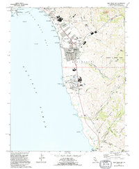 1991 Half Moon Bay1995 Print · USGSCoastal San Mateo County in the early nineties reveals a blend of seaside settlement and deep canyon ranching. Trace local history through the Lobitos Schoolhouse, the Pillar Point Air Force Station, and the Ioof Cem.
 - 1997 Map of Half Moon Bay, 1999 Print
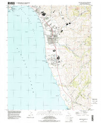 1997 Half Moon Bay1999 Print · USGSThe San Mateo coastline comes alive in the late nineties, showing the growth of coastal towns from Miramar down to the southern bluffs. Researchers can trace the layout of Lobitos, locate the IOOF Cem, or study the boundaries of the Burleigh H Murray Ranch State Park.
End of results
Showing maps 1-2 of 2
Top cities near Martins Beach
- Hayward historical maps
- San Mateo historical maps
- Redwood City historical maps
- Palo Alto historical maps
- Pacifica historical maps
- Menlo Park historical maps
See more
Frequently asked questions
- What are the different types of historical maps available for Martins Beach?
- What is the oldest map of Martins Beach?
- Where can I purchase historical maps of Martins Beach for my home or office?
- Where can I download high-res historical maps of Martins Beach?
- Are there historical topographic maps available for Martins Beach?
- Is there historical aerial imagery available for Martins Beach?
- Where are historical maps of Martins Beach sourced from?