Old Maps of Edgemar, Pacifica for Academic Research
Study the evolution of Edgemar with 26 high-resolution historic maps. Whether you're teaching, researching, or modeling changes in land use, these maps provide essential visual documentation of urban, environmental, and geographic change.
- Analyze long-term change: Track patterns in development, transportation, and natural features.
- Ideal for environmental or urban studies: Support academic projects with primary historical map data.
- Use in the classroom or lab: Educators and researchers rely on these maps to bring historical context to life.
These maps are a powerful tool for teaching, research, and visualizing how Edgemar has changed over the decades.
Edgemar, Pacifica maps
(26)- 1892 Map of San Mateo
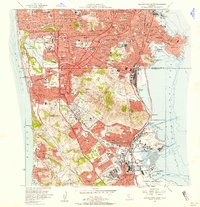
 1892 San Mateo1892 Print · USGSThe San Francisco Peninsula in the 1890s reveals a landscape of ranchos and rising rail towns. Trace the early footprints of Colma, Millbrae, and South San Francisco alongside vital water infrastructure like the Crystal Springs Dam.
 - 1896 Map of San Mateo
 1896 San Mateo1896 Print · USGSThe northern San Francisco Peninsula comes alive in this late nineteenth-century survey. Genealogists and historians can trace early trackage of the Southern Pacific R. R. through Colma and Millbrae, or locate the Industrial School and Brewer School.
 - 1899 Map of San Mateo
 1899 San Mateo1899 Print · USGSThe northern San Mateo peninsula appears here in the late nineteenth century as a landscape of early rail lines and critical water infrastructure. Trace the early development of South San Francisco, the sprawling Cemeteries of Colma, and rural schoolhouses like Hoyt School.6 unique versions available
 - 1915 Map of San Mateo
 1915 San Mateo1915 Print · USGSThe San Francisco Peninsula at the start of the twentieth century shows a landscape transitioning from rural ranchos to industrial centers and suburbs. Genealogists can trace family footprints at Colma, locate the Hoyt School, or follow the Southern Pacific RR through Baden Sta.6 unique versions available
 - 1939 Map of San Mateo, 1956 Print
 1939 San Mateo1956 Print · USGSThe San Francisco Peninsula at the brink of the 1940s reveals a landscape of ridge-top vistas and growing railroad towns. Researchers can trace the early layouts of Burlingame, San Bruno, and Millbrae, or locate institutional landmarks like St Josephs Military Academy and the extensive Chinese Cem.3 unique versions available
 - 1943 Map of San Mateo
 1943 San Mateo1943 Print · USGSThe San Francisco Peninsula during the mid-war years shows a region of expanding shoreline industry and established hillside communities. Researchers can trace historic landmarks like St Josephs Military Academy and the Golden Gate National Cem.
 - 1947 Map of San Francisco, 1948 Print
 1947 San Francisco1948 Print · USGSThe Bay Area in the late 1940s reveals a region transitioning from wartime intensity to post-war suburban growth. Trace the historic rail lines of the Southern Pacific RR or locate early military footprints at Fort Funston and Moffett Field.
 - 1947 Map of San Francisco South, 1955 Print
 1947 San Francisco South1955 Print · USGSPost-war San Mateo County and the city's southern edge are caught here during a period of rapid peninsula growth. Genealogists can trace the many memorial grounds of Colma, while historians can locate the Tanforan Race Track and early San Francisco International Airport.
 - 1948 Map of San Francisco, 1951 Print
 1948 San Francisco1951 Print · USGSThe Bay Area in the late 1940s reveals a landscape defined by rapid post-war growth and a heavy military presence at the Golden Gate. Trace the development of early trans-bay infrastructure like the Oakland-Bay Bridge and historic coastal defense sites such as Fort Funston and Alcatraz Island.
 - 1950 Map of San Francisco South
 1950 San Francisco South1950 Print · USGSThe San Francisco peninsula mid-century is a landscape of rapid suburban growth and massive memorial parks. Trace the historic grounds of the Tanforan Race Track, the early runways of the International Airport, and the sprawling Golden Gate National Cemetery.
 - 1955 Map of San Francisco
 1955 San Francisco1955 Print · USGSThe San Francisco Bay Area and central coast are captured during the postwar boom as suburbs and infrastructure expanded rapidly. Trace the development of local communities and military installations like the Presidio and Fort Mason, or follow the Southern Pacific rail lines.
 - 1956 Map of San Francisco
 1956 San Francisco1956 Print · USGSThe San Francisco Bay Area is captured in the mid-fifties, showing a landscape of rapid post-war growth and massive military installations. Researchers can trace the sprawling rail lines of the Southern Pacific and locate historic sites like Stanford University or the Hunters Point Naval Shipyard.4 unique versions available
 - 1956 Map of San Francisco South, 1958 Print
 1956 San Francisco South1958 Print · USGSThe San Francisco peninsula transitioned into a post-war suburban and industrial hub during the mid-fifties. Researchers can trace the vast cemetery complex of Colma, the early layout of San Francisco International Airport, and the Naval Reservation at South Basin.6 unique versions available
 - 1957 Map of San Francisco
 1957 San Francisco1957 Print · USGSThe Bay Area in the mid-fifties reveals a rapidly growing metropolitan landscape connected by its iconic spans and rail networks. Researchers can trace the layout of military sites like the Presidio and the extent of the Southern Pacific and Western Pacific railroads.
 - 1960 Map of San Francisco
 1960 San Francisco1960 Print · USGSThe San Francisco Bay Area at the start of the sixties reveals a landscape of rapid expansion and critical infrastructure. Researchers can trace the development of East Bay communities like Russell City and Mt Eden or locate early rural landmarks like Alpine School.
 - 1961 Map of San Francisco
 1961 San Francisco1961 Print · USGSThe Bay Area at the dawn of the 1960s reveals a landscape of growing cities and massive Cold War military installations. Genealogists and historians can trace the mid-century urban footprint from Berkeley to San Mateo, while locating landmarks like the Presidio, Alcatraz Island, and Moffett Field Air Station.
 - 1964 Map of San Francisco
 1964 San Francisco1964 Print · USGSThe Bay Area in the mid-sixties shows a region of rapid suburban expansion and major military installations. Researchers can trace the development of the South Bay near Stanford University or locate family plots in the historic Cypress Lawn Cem and Holy Cross Cem.
 - 1971 Map of San Francisco
 1971 San Francisco1971 Print · USGSThe San Francisco Bay Area at the start of the 1970s is shown here as a dense network of aerospace hubs, naval bases, and expanding suburbs. Researchers can trace the mid-century footprint of Stanford University, the industrial Salt Evaporators, and the Southern Pacific rail lines.
 - 1978 Map of San Francisco, 1979 Print
 1978 San Francisco1979 Print · USGSThe San Francisco Bay Area in the late seventies reveals a landscape where massive naval installations and federal parklands meet a rapidly maturing urban core. Genealogists and historians can locate family landmarks near the National Cemetery, trace the Southern Pacific rail lines, or study the layout of the Alameda Naval Air Station.2 unique versions available
 - 1985 Map of San Francisco, 1989 Print
 1985 San Francisco1989 Print · USGSThe Bay Area is captured in the mid-1980s through experimental Landsat satellite imagery, offering a unique technological perspective of the California coast. Trace the urban boundaries of San Francisco and Alameda against the San Francisco Bay and Lorenzo.
 - 1993 Map of San Francisco South, 1997 Print
 1993 San Francisco South1997 Print · USGSThe northern San Francisco Peninsula in the early nineties reveals a landscape of dense suburbs and major infrastructure. Genealogists can trace the vast memorial parks of Colma like Italian Cemetery, while others can locate the Cow Palace and Candlestick Point.
 - 1995 Map of San Francisco South, 1999 Print
 1995 San Francisco South1999 Print · USGSThe northern Peninsula in the mid-nineties shows the dense cemeteries of Colma and the industrial waterfront of South San Francisco. Trace family history and local landmarks from Holy Cross Cemetery to the Cow Palace and Candlestick Park Stadium.
 - 2012 Map of San Francisco South, 2012 Print
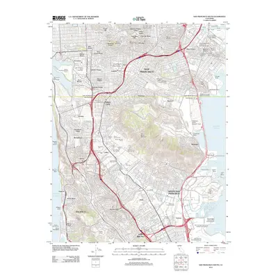 2012 San Francisco South2012 Print · USGSCovers Edgemar, including San Francisco, Daly City, and other nearby areas
 - 2015 Map of San Francisco South, 2015 Print
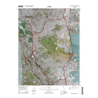 2015 San Francisco South2015 Print · USGSCovers Edgemar, including San Francisco, Daly City, and other nearby areas
 - 2018 Map of San Francisco South, 2018 Print
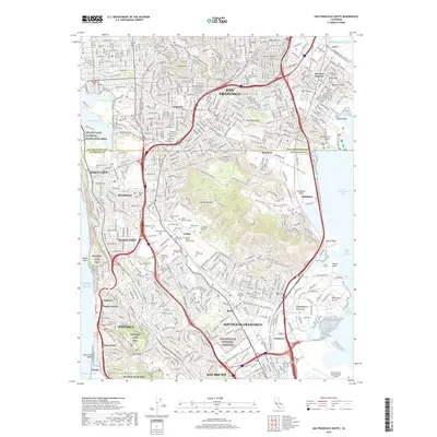 2018 San Francisco South2018 Print · USGSCovers Edgemar, including San Francisco, Daly City, and other nearby areas
Showing maps 1-25 of 26
Frequently asked questions
- What are the different types of historical maps available for Edgemar?
- What is the oldest map of Edgemar?
- Where can I purchase historical maps of Edgemar for my home or office?
- Where can I download high-res historical maps of Edgemar?
- Are there historical topographic maps available for Edgemar?
- Is there historical aerial imagery available for Edgemar?
- Where are historical maps of Edgemar sourced from?