1980s Maps of Los Olivos, California
Explore 2 historic maps of Los Olivos from the 1980s. These maps offer a rare glimpse into what life looked like during the 1980s — showing old roads, neighborhoods, homes, and landmarks that have changed or disappeared over time.
Whether you're researching your family's past, planning a metal detecting trip, or studying how Los Olivos's landscape evolved across the 1980s, these high-resolution maps are a powerful tool for exploring the history of this region.
- Focus on a specific era: All maps on this page are from the 1980s, giving you a focused view of this time period.
- See what’s changed: Compare century-old streets, trails, and buildings to today's modern landscape using overlays and satellite layers.
- Research with precision: Use these maps for genealogy, historical research, land use analysis, or educational projects.
- View, download, or print: Maps are fully viewable online in high resolution, and can be downloaded or printed for your own records.
Start exploring Los Olivos's history through authentic maps from the 1980s. This is your window into the past.
Los Olivos, CA maps
(2)- 1982 Map of Santa Maria, 1983 Print
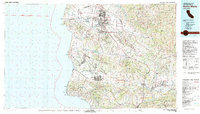 1982 Santa Maria1983 Print · USGSSanta Barbara County in the early eighties shows the expansion of the Central Coast, from the military grounds of the shoreline to the inland valleys. You can trace the Southern Pacific rail lines and locate landmarks like Betteravia, Los Alamos, and the La Purisima Mission State Historical Mon.2 unique versions available
 - 1989 Map of Santa Maria, 1991 Print
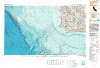 1989 Santa Maria1991 Print · USGSThe Central Coast in the late eighties reveals a landscape of massive coastal installations and deep-rooted agricultural valleys. Genealogists and researchers can trace the Southern Pacific line through Guadalupe or locate landmarks like Betteravia and the La Purisima Mission State Historical Monument.
End of results
Showing maps 1-2 of 2
Top cities near Los Olivos
- Goleta historical maps
- Solvang historical maps
- Santa Ynez historical maps
- Buellton historical maps
- Ballard historical maps
Frequently asked questions
- What are the different types of historical maps available for Los Olivos?
- What is the oldest map of Los Olivos?
- Where can I purchase historical maps of Los Olivos for my home or office?
- Where can I download high-res historical maps of Los Olivos?
- Are there historical topographic maps available for Los Olivos?
- Is there historical aerial imagery available for Los Olivos?
- Where are historical maps of Los Olivos sourced from?