Old Maps of Shepards, California for Metal Detecting
Plan your next treasure hunt with 14 historic maps of Shepards. Find old homesites, ghost towns, trails, and gathering spots that may be lost to time — perfect for identifying promising metal detecting locations.
- Locate forgotten sites: Uncover places like long-lost settlements, abandoned rail lines, or gathering spots.
- Plan better hunts: Use map overlays combined with LiDAR or satellite views to narrow in on historically rich areas.
- Made for detectorists: Thousands of hobbyists use these maps to discover relics, coins, and hidden history.
Use these historic maps to boost your research and find new opportunities beneath the surface of Shepards.
Shepards, CA maps
(14)- 1904 Map of Ventura
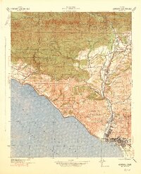
 1904 Ventura1904 Print · USGSThe coastal shelf and interior valleys of Ventura County appear here in the early twentieth century, showing a landscape of ranchos and new rail lines. Genealogists and historians can locate early settlements like Matilija and Oakview or trace the Southern Pacific RR along the Santa Barbara Channel.6 unique versions available
 - 1941 Map of Ventura
 1941 Ventura1941 Print · USGSCoastal Ventura and the Ojai Valley are shown in the early 1940s, just as the region began its mid-century growth. Genealogists and historians can trace family properties like the Schafer Farm, locate the historic Matilija Hot Springs, or follow the Southern Pacific rail line.4 unique versions available
 - 1949 Map of Los Angeles
 1949 Los Angeles1949 Print · USGSSouthern California and the South Coast appear at the onset of the post-war boom, from the Channel Islands to the Mojave Desert. Trace early aviation sites like Lockheed Air Terminal and mining history at the Redrock Quicksilver Mine and Redrover Mine.2 unique versions available
 - 1952 Map of White Ledge Peak, 1953 Print
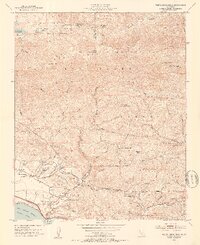 1952 White Ledge Peak1953 Print · USGSThe Santa Barbara coast and its inland mountains are captured here in the early fifties, showing the interplay of ranching and early aviation. Genealogists can trace family landmarks like Botello Ranch, locate the Cate School, or study the remote Billiard Flats.6 unique versions available
 - 1955 Map of Los Angeles
 1955 Los Angeles1955 Print · USGSThe mid-century transformation of Southern California comes into focus as the urban sprawl of Los Angeles meets the wilderness of the Santa Monica Mountains. Researchers can trace the development of post-war suburbs alongside historic landmarks like the Santa Barbara Lighthouse and early industrial sites such as the Good Luck Mine.
 - 1959 Map of Los Angeles
 1959 Los Angeles1959 Print · USGSCoastal California and the high desert met in a period of booming growth after the war. Researchers can trace early aviation and military history at the Point Mugu Air Missile Test Ctr or locate desert mining sites like the Double Eagle Mine.3 unique versions available
 - 1966 Map of Los Angeles
 1966 Los Angeles1966 Print · USGSSouthern California underwent a mid-century transformation as suburban grids reached the base of the San Gabriel Mountains. Researchers can trace the path of the Los Angeles Aqueduct or locate defense landmarks like Edwards Air Force Base.
 - 1975 Map of Los Angeles, 1977 Print
 1975 Los Angeles1977 Print · USGSSouthern California is captured in a period of significant growth during the mid-seventies, showing the urban sprawl from the coast to the high desert. Researchers can trace the development of the Pacific Coast Hwy and find aerospace landmarks like Edwards Air Force Base and the Flight Test Center (NASA).2 unique versions available
 - 1982 Map of Santa Barbara, 1983 Print
 1982 Santa Barbara1983 Print · USGSCoastal California in the early eighties exhibits a landscape of growing cities and massive military and academic footprints. Genealogists and historians can trace the Southern Pacific rail line through Santa Barbara or explore the boundaries of historic ranchos like Las Positas y Calera.3 unique versions available
 - 1995 Map of White Ledge Peak, 2000 Print
 1995 White Ledge Peak2000 Print · USGSVentura and Santa Barbara Counties meet in the mid-nineties along a rugged coastline where the national forest meets the sea. Researchers can trace the layout of the Cate School, find the Rincon Station, and locate backcountry landmarks like Jameson Lake and Bonito Ranch.
 - 2012 Map of White Ledge Peak, 2012 Print
 2012 White Ledge Peak2012 Print · USGSCovers Shepards, including Carpinteria, Ventura County, and other nearby areas
 - 2015 Map of White Ledge Peak, 2015 Print
 2015 White Ledge Peak2015 Print · USGSCovers Shepards, including Carpinteria, Ventura County, and other nearby areas
 - 2018 Map of White Ledge Peak, 2018 Print
 2018 White Ledge Peak2018 Print · USGSCovers Shepards, including Carpinteria, Ventura County, and other nearby areas
 - 2022 Map of White Ledge Peak, 2022 Print
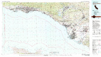
 2022 White Ledge Peak2022 Print · USGSThe Ventura County coast meets the steep Santa Ynez range in the early twenty-twenties, showing a landscape of coastal agriculture and protected forest. Researchers can trace land use from the shoreline of Carpinteria to mountain landmarks like White Ledge Peak and Murietta Dam.
End of results
Showing maps 1-14 of 14
Top cities near Shepards
- Oxnard historical maps
- Ventura historical maps
- Santa Barbara historical maps
- Carpinteria historical maps
- Montecito historical maps
- Ojai historical maps
See more
Frequently asked questions
- What are the different types of historical maps available for Shepards?
- What is the oldest map of Shepards?
- Where can I purchase historical maps of Shepards for my home or office?
- Where can I download high-res historical maps of Shepards?
- Are there historical topographic maps available for Shepards?
- Is there historical aerial imagery available for Shepards?
- Where are historical maps of Shepards sourced from?