1900s (20th Century) Maps of Ingot, California
Explore 6 historic maps of Ingot from the 1900s (20th Century). These maps offer a rare glimpse into what life looked like during the 1900s — showing old roads, neighborhoods, homes, and landmarks that have changed or disappeared over time.
Whether you're researching your family's past, planning a metal detecting trip, or studying how Ingot's landscape evolved across the 1900s, these high-resolution maps are a powerful tool for exploring the history of this region.
- Focus on a specific era: All maps on this page are from the 1900s, giving you a focused view of this time period.
- See what’s changed: Compare century-old streets, trails, and buildings to today's modern landscape using overlays and satellite layers.
- Research with precision: Use these maps for genealogy, historical research, land use analysis, or educational projects.
- View, download, or print: Maps are fully viewable online in high resolution, and can be downloaded or printed for your own records.
Start exploring Ingot's history through authentic maps from the 1900s. This is your window into the past.
Ingot, CA maps
(6)- 1901 Map of Redding
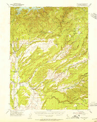
 1901 Redding1901 Print · USGSShasta County's northern canyon and mining districts come into focus at the dawn of the twentieth century. Researchers can trace the original rail stops at Kennett and Keswick or locate early industrial sites like the Bully Hill Mine and Baird Fish Hatchery.7 unique versions available
 - 1953 Map of Millville, 1955 Print
 1953 Millville1955 Print · USGSShasta County transitions from the valley floor to the forested ridges of the southern Cascades during the 1950s. Genealogists can locate family names at the Masonic Cem and Odd Fellows Cem or trace vanished locales like Tollgate (Site).3 unique versions available
 - 1958 Map of Redding
 1958 Redding1958 Print · USGSNorthern California's valley and mountain landscapes are captured in the late fifties, showing the region as new reservoirs reshaped the river systems. Genealogists and historians can trace rail-side towns like Cottonwood, the military presence at Red Bluff Air Force Station, and mountain outposts like Weaverville.5 unique versions available
 - 1984 Map of Redding
 1984 Redding1984 Print · USGSThe Shasta County region in the mid-1980s reveals a landscape of massive reservoirs and active mining districts. Researchers can trace the development of Redding and Enterprise or locate historic mineral sites like Iron Mountain Mine and Keystone Mine.2 unique versions available
 - 1985 Map of Oak Run, 1986 Print
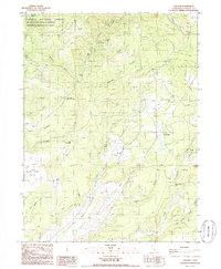 1985 Oak Run1986 Print · USGSShasta County mining and ranching lands come into focus in the mid-1980s as the area transitioned away from its early industrial roots. Genealogists and historians can trace the sites of Ingot, Tollgate (Site), and remote workings like the Coronado Mine.
 - 1998 Map of Oak Run, 2003 Print
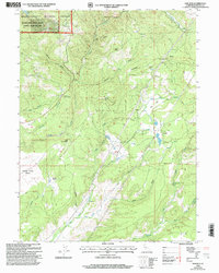 1998 Oak Run2003 Print · USGSShasta County during the late twentieth century reveals a rugged landscape of mining heritage and mountain settlements. Genealogists and historians can trace the foundations of Ingot, the remote Tollgate Site, and mining remains like the Donkey Mine.
End of results
Showing maps 1-6 of 6
Top cities near Ingot
Frequently asked questions
- What are the different types of historical maps available for Ingot?
- What is the oldest map of Ingot?
- Where can I purchase historical maps of Ingot for my home or office?
- Where can I download high-res historical maps of Ingot?
- Are there historical topographic maps available for Ingot?
- Is there historical aerial imagery available for Ingot?
- Where are historical maps of Ingot sourced from?