1930s Maps of Klamath River, California
Explore 2 historic maps of Klamath River from the 1930s. These maps offer a rare glimpse into what life looked like during the 1930s — showing old roads, neighborhoods, homes, and landmarks that have changed or disappeared over time.
Whether you're researching your family's past, planning a metal detecting trip, or studying how Klamath River's landscape evolved across the 1930s, these high-resolution maps are a powerful tool for exploring the history of this region.
- Focus on a specific era: All maps on this page are from the 1930s, giving you a focused view of this time period.
- See what’s changed: Compare century-old streets, trails, and buildings to today's modern landscape using overlays and satellite layers.
- Research with precision: Use these maps for genealogy, historical research, land use analysis, or educational projects.
- View, download, or print: Maps are fully viewable online in high resolution, and can be downloaded or printed for your own records.
Start exploring Klamath River's history through authentic maps from the 1930s. This is your window into the past.
Klamath River, CA maps
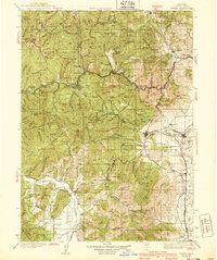
(2)- 1932 Map of Yreka
 1932 Yreka1932 Print · USGSSiskiyou County at the dawn of the 1930s shows a landscape of mountain mining claims and developing valley towns. Genealogists can trace family roots through numerous rural school districts like Lane Star Sch and mining sites including the Norma Mine and McKinley Mine.
 - 1939 Map of Yreka
 1939 Yreka1939 Print · USGSSiskiyou County's mining and ranching valleys are captured here in the late 1930s, showing the early infrastructure of the Klamath River corridor. Trace the old rail stops at Hornbrook and Montague or locate family-named sites like Shasta River Sch and Cinnabar Mine.2 unique versions available
End of results
Showing maps 1-2 of 2
Top cities near Klamath River
Frequently asked questions
- What are the different types of historical maps available for Klamath River?
- What is the oldest map of Klamath River?
- Where can I purchase historical maps of Klamath River for my home or office?
- Where can I download high-res historical maps of Klamath River?
- Are there historical topographic maps available for Klamath River?
- Is there historical aerial imagery available for Klamath River?
- Where are historical maps of Klamath River sourced from?